Eppley Airfield | |||||||||||||||||||
|---|---|---|---|---|---|---|---|---|---|---|---|---|---|---|---|---|---|---|---|
 The OMA logo, styled after the Dance of the Cranes statue situated on the airport grounds | |||||||||||||||||||
 Eppley Airfield in December 2006 | |||||||||||||||||||
| Summary | |||||||||||||||||||
| Owner/Operator | Omaha Airport Authority | ||||||||||||||||||
| Serves | Eastern Nebraska and Western Iowa | ||||||||||||||||||
| Location | 4501 Abbott Drive Omaha, Nebraska, U.S. | ||||||||||||||||||
| Elevation AMSL | 984 ft / 300 m | ||||||||||||||||||
| Coordinates | 41°18′00″N 95°53′42″W / 41.30°N 95.895°W | ||||||||||||||||||
| Website | flyoma.com | ||||||||||||||||||
| Maps | |||||||||||||||||||
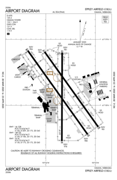
 FAA airport diagram | |||||||||||||||||||
 | |||||||||||||||||||
| Runways | |||||||||||||||||||
| |||||||||||||||||||
| Statistics (2023) | |||||||||||||||||||
| |||||||||||||||||||
Eppley Airfield (IATA: OMA, ICAO: KOMA, FAA LID: OMA), also known as Omaha Airport, is an airport in the midwestern United States, located three miles (5 km) northeast of downtown Omaha, Nebraska. On the west bank of the Missouri River in Douglas County, it is the largest airport in Nebraska, with more arrivals and departures than all other airports in the state combined. It is classified as a medium hub airport by the Federal Aviation Administration (FAA). It is owned and operated by the Omaha Airport Authority (OAA).
- ^ FAA Airport Form 5010 for OMA PDF, effective October 31, 2024
- ^ Eppley Airfield, official website
- ^ "Eppley Airfield 2023 Statistics" (PDF). flyoma.com. Retrieved January 31, 2024.