Erikoussa
Ερεικούσσα | |
|---|---|
 | |
| Coordinates: 39°53′N 19°35′E / 39.883°N 19.583°E | |
| Country | Greece |
| Administrative region | Ionian Islands |
| Regional unit | Corfu |
| Municipality | Central Corfu and Diapontian Islands |
| Area | |
| • Municipal unit | 4.449 km2 (1.718 sq mi) |
| Population (2021)[1] | |
| • Municipal unit | 447 |
| • Municipal unit density | 100/km2 (260/sq mi) |
| Time zone | UTC+2 (EET) |
| • Summer (DST) | UTC+3 (EEST) |
| Website | www |
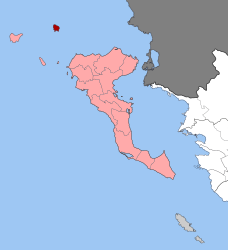
Erikoussa (Greek: Ερεικούσσα) is an island and a former community of the Ionian Islands, Greece. It is one of the Diapontian Islands; an island complex to the northwest of Corfu. Since the 2019 local government reform it is part of the municipality of Central Corfu and Diapontian Islands, of which it is a municipal unit.[2] It is located off the northwestern coast of the island of Corfu, and is almost equidistant from Corfu to the southeast, Mathraki to the southwest, and Othonoi to the west. Its population was 447 in the 2021 census, and its land area is 3.65 square kilometres (1 sq mi). The municipal unit has an area of 4.449 km2.[3] It has six settlements; the main one is Porto (Πόρτο), which is also where the only port is located.[4][5] The island has dense vegetation and three beaches; Porto (Πόρτο), Bragini (Μπραγκίνι), and Fiki (Φύκι).[5][6] The name Ereikoussa derives from the plant ereíki (ερείκη), which can be found throughout the island.[4][5][6]
- ^ "Αποτελέσματα Απογραφής Πληθυσμού - Κατοικιών 2021, Μόνιμος Πληθυσμός κατά οικισμό" [Results of the 2021 Population - Housing Census, Permanent population by settlement] (in Greek). Hellenic Statistical Authority. 29 March 2024.
- ^ "Τροποποίηση του άρθρου 1 του ν. 3852/2010" [Amendment of Article 1 of l. 3852/2010] (in Greek). Government Gazette. p. 1164.
- ^ "Population & housing census 2001 (incl. area and average elevation)" (PDF) (in Greek). National Statistical Service of Greece. Archived from the original (PDF) on 2015-09-21.
- ^ a b "Διαπόντια Νησιά: Το "άγνωστο" δυτικότερο άκρο της Ελλάδας (φωτο)". Pronews.gr (in Greek). 11 June 2019. Retrieved 24 June 2022.
- ^ a b c "10 εναλλακτικά και άγνωστα παραδεισένια νησιά της Ελλάδας". Lifo (in Greek). 19 August 2019. Retrieved 24 June 2022.
- ^ a b "Μια σταλιά νησάκι, σαν από άλλη εποχή: Η "γαλάζια λίμνη" του Ιονίου που ανταγωνίζεται στα ίσα Κέρκυρα και Κεφαλονιά". Ethnos (in Greek). 24 May 2022. Retrieved 24 June 2022.

