Erma, New Jersey | |
|---|---|
 Erma Volunteer Fire Company | |
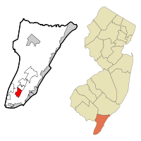
 Map of Erma CDP in Cape May County. Inset: Location of Cape May County in New Jersey. | |
| Coordinates: 38°59′49″N 74°53′28″W / 38.996931°N 74.891122°W | |
| Country | |
| State | |
| County | Cape May |
| Township | Lower |
| Area | |
• Total | 3.01 sq mi (7.80 km2) |
| • Land | 2.92 sq mi (7.55 km2) |
| • Water | 0.10 sq mi (0.25 km2) 2.97% |
| Elevation | 10 ft (3 m) |
| Population | |
• Total | 2,031 |
| • Density | 696.26/sq mi (268.84/km2) |
| Time zone | UTC−05:00 (Eastern (EST)) |
| • Summer (DST) | UTC−04:00 (Eastern (EDT)) |
| ZIP Code | |
| Area code | 609 |
| FIPS code | 34-21660[5][6][7] |
| GNIS feature ID | 02389049[5][8] |
Erma is an unincorporated community and census-designated place (CDP)[9] located within Lower Township in Cape May County, in the U.S. state of New Jersey.[10] As of the 2020 United States census, the CDP's population was 2,031,[3] a decline of 103 from the 2010 census count of 2,134.[11]
- ^ "ArcGIS REST Services Directory". United States Census Bureau. Retrieved October 11, 2022.
- ^ U.S. Geological Survey Geographic Names Information System: Erma Census Designated Place, Geographic Names Information System. Accessed October 18, 2012.
- ^ a b Census Data Explorer: Erma CDP, New Jersey, United States Census Bureau. Accessed June 15, 2023.
- ^ Look Up a ZIP Code for Erma, NJ, United States Postal Service. Accessed October 18, 2012.
- ^ a b Gazetteer of New Jersey Places, United States Census Bureau. Accessed July 21, 2016.
- ^ U.S. Census website, United States Census Bureau. Accessed September 4, 2014.
- ^ Geographic Codes Lookup for New Jersey, Missouri Census Data Center. Accessed June 9, 2023.
- ^ US Board on Geographic Names, United States Geological Survey. Accessed September 4, 2014.
- ^ State of New Jersey Census Designated Places - BVP20 - Data as of January 1, 2020, United States Census Bureau. Accessed December 1, 2022.
- ^ New Jersey: 2010 - Population and Housing Unit Counts - 2010 Census of Population and Housing (CPH-2-32), United States Census Bureau, August 2012. Accessed October 18, 2012.
- ^ DP-1 - Profile of General Population and Housing Characteristics: 2010 Demographic Profile Data for Erma CDP, New Jersey Archived 2020-02-12 at archive.today, United States Census Bureau. Accessed October 18, 2012.


