Ermoupoli
Ερμούπολη | |
|---|---|
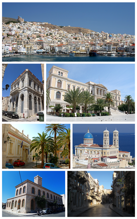
 Clockwise from top: Panoramic view of the City of Ermoupoli, the Miaouli Square and the City Hall of Ermoupoli, Cathedral of Saint Nicholas, a central street in Ermoupoli, Industrial Museum of Ermoupoli, Building of the South Aegean Administration, and characteristic examples of urban architecture in Ermoupoli. | |
| Coordinates: 37°26′N 24°55′E / 37.433°N 24.917°E | |
| Country | Greece |
| Administrative region | South Aegean |
| Regional unit | Syros |
| Municipality | Syros-Ermoupoli |
| Area | |
| • Municipal unit | 11.2 km2 (4.3 sq mi) |
| Elevation | 20 m (70 ft) |
| Population (2021)[1] | |
| • Municipal unit | 13,399 |
| • Municipal unit density | 1,200/km2 (3,100/sq mi) |
| • Community | 11,039 |
| Time zone | UTC+2 (EET) |
| • Summer (DST) | UTC+3 (EEST) |
| Postal code | 841 00 |
| Area code(s) | 22810 |
| Vehicle registration | ΕΜ |
| Website | www.hermoupolis.gr |
Ermoupoli (Greek: Ερμούπολη), also known by the formal older name Ermoupolis or Hermoupolis (Greek: Ἑρμούπολις < Ἑρμοῦ πόλις "Town of Hermes"), is a town and former municipality on the island of Syros, in the Cyclades, Greece. Since the 2011 local government reform, it is part of the municipality Syros-Ermoupoli, of which it is the seat and a municipal unit.[2] It is also the capital of the South Aegean region. The municipal unit has an area of 11.181 km2.[3]
- ^ "Αποτελέσματα Απογραφής Πληθυσμού - Κατοικιών 2021, Μόνιμος Πληθυσμός κατά οικισμό" [Results of the 2021 Population - Housing Census, Permanent population by settlement] (in Greek). Hellenic Statistical Authority. 29 March 2024.
- ^ "ΦΕΚ B 1292/2010, Kallikratis reform municipalities" (in Greek). Government Gazette.
- ^ "Population & housing census 2001 (incl. area and average elevation)" (PDF) (in Greek). National Statistical Service of Greece. Archived from the original (PDF) on 2015-09-21.


