Erp | |
|---|---|
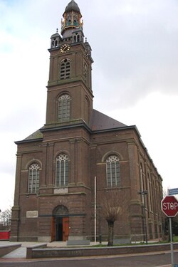
 St. Servatius Church in Erp, 1844 | |
| Coordinates: 51°36′0″N 5°36′26″E / 51.60000°N 5.60722°E | |
| Country | Netherlands |
| Province | North Brabant |
| Municipality | Meierijstad |
| Incorporated | 1300 |
| Market rights | 1789 |
| Annexed | 1994 |
| Area | |
| • Total | 6.20 km2 (2.39 sq mi) |
| Elevation | 11 m (36 ft) |
| Population (2021)[1] | |
| • Total | 1,800 |
| • Density | 290/km2 (750/sq mi) |
| Demonym | Erpenaar |
| Time zone | UTC+1 (CET) |
| • Summer (DST) | UTC+2 (CEST) |
| Postal code | 5469[1] |
| Dialing code | 0413 |
| Major roads | N279 |
Erp (Dutch pronunciation: [ˈɛr(ə)p]) is a village in southern Netherlands, in the province of North Brabant between 's-Hertogenbosch and Eindhoven. Prior to 1994, Erp was a municipality consisting of the town of Erp and the villages of Boerdonk and Keldonk. In that year, the municipality was merged with the municipality of Veghel to form one municipality under the latter name. The area of the former municipality of Erp has a population of 6,663, while Veghel has a population of 37,655.
The municipality of Veghel, which merged into the new municipality of Meierijstad in 2017, consisted of the towns of Veghel and Erp, and the villages of Boerdonk, Keldonk, Mariaheide, Zijtaart and Eerde. Veghel is 5 km northwest of Erp and other neighboring towns, including Uden (north), Boekel (east), Gemert (southeast), Beek en Donk (south) and Sint-Oedenrode (west).
Erp's town hall dates from 1791. It lost its main function when Erp was annexed to Veghel. Both the town hall and the Saint Servatius Church are on the national list of historic preservation.
- ^ a b c "Kerncijfers wijken en buurten 2021". Central Bureau of Statistics. Retrieved 17 April 2022.
three entries
- ^ "Postcodetool for 5469AA". Actueel Hoogtebestand Nederland (in Dutch). Het Waterschapshuis. Retrieved 17 April 2022.


