Esino Lario | |
|---|---|
| Comune di Esino Lario | |
 Lower Esino Lario | |
 Location in the province of Lecco | |
| Coordinates: 45°59′40″N 9°19′58″E / 45.9945°N 9.3327°E | |
| Country | Italy |
| Region | Lombardy |
| Province | Lecco (LC) |
| Frazioni | Bigallo, Ortanella |
| Government | |
| • Mayor | Pietro Pensa |
| Area | |
| • Total | 18.05 km2 (6.97 sq mi) |
| Elevation | 913 m (2,995 ft) |
| Population (31 July 2017)[2] | |
| • Total | 747 |
| • Density | 41/km2 (110/sq mi) |
| Demonym | Esinesi |
| Time zone | UTC+1 (CET) |
| • Summer (DST) | UTC+2 (CEST) |
| Postal code | 23825 |
| Dialing code | 0341 |
| Patron saint | St. Victor |
| Saint day | 8 May |
| Website | Official website |
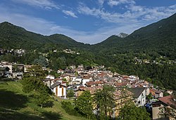
Esino Lario (Italian pronunciation: [ˈeːzino ˈlaːrjo]; Lecchese: Esin [ˈeːzĩ]; locally Isen [ˈiːzẽ]) is a municipality (comune) of the Province of Lecco in the Italian region of Lombardy. It is about 60 kilometres (37 mi) north of Milan, 15 kilometres (9.3 mi) northwest of Lecco, and about 4.3 kilometres (2.7 mi) from the eastern shore of Lake Como.
The area around Esino Lario is surrounded by Alpine mountains, where the karst landscape has produced sink-holes and caves, including the "Icebox of Moncodeno".[3] The municipality is part of the Mountain Community of Valsassina, Valvarrone, Val d'Esino, and Riviera and is entirely within the "Regional Park of Northern Grigna" (Parco delle Grigna Settentrionale).
Esino Lario borders the municipalities of Cortenova, Lierna, Mandello del Lario, Parlasco, Pasturo, Perledo, Primaluna, Taceno, and Varenna.
- ^ "Superficie di Comuni Province e Regioni italiane al 9 ottobre 2011". Italian National Institute of Statistics. Retrieved 16 March 2019.
- ^ All demographics and other statistics: Italian statistical institute Istat.
- ^ Cite error: The named reference
intergrignawas invoked but never defined (see the help page).


