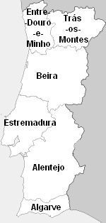
Estremadura Province (to 1933) | |
|---|---|
 | |
 | |
| Country | Portugal |
Estremadura Province (1933–1959) | |
|---|---|
 | |
 | |
| Coordinates: 39°15′00″N 09°10′00″W / 39.25000°N 9.16667°W | |
| Country | Portugal |
Estremadura Province (European Portuguese pronunciation: [(i)ʃtɾɨmɐˈðuɾɐ]) is one of the six historical provinces of Portugal.
It is located along the Atlantic Ocean coast in the center of the country and includes Lisbon, the capital. The name of this province (and also the Spanish Extremadura) originates from the Spanish and Portuguese struggle with the Moors, and the Christian military victories over the Moors (moros) during the 12th century. These provinces were called Extrema Durii, which means "farthest from the Douro River."[1][2]
During the 19th century, Estremadura was the only province in the kingdom that did not border Spain. The provinces Beira and Alentejo bordered on the north, east, and south. Its 164-mile (264 km) western border was with the Atlantic Ocean, and it was 85 miles (137 km) wide at its widest point.[3]
In 1835, Portugal divided into districts, which were subdivided into counties and parishes. Estremadura Province included Districts of Lisbon, Santarém, Leiria and part of Setúbal with Lisboa as its capital.[3] Maps from this time show six provinces, of which Estremadura was one, but this was not official with the government.[3]
On 22 February 1933, Portugal was divided into eleven provinces. Today, continental Portugal is divided into 18 administrative districts, each with a district capital. However, the historic provinces (1933–1959) continue to be used in everyday life despite the new district system.[4]
- ^ Fairburn, John (1808). A Statistical and Geographical Survey of Spain and Portugal ... London: J. Dennet. pp. 133–145.
- ^ Publications, Inc Fodor's Travel (2005). Fodor's Portugal. Fodor's Travel Publications. p. 77. ISBN 9781400014521.
- ^ a b c Law, Gwillim (2010-11-19). Administrative Subdivisions of Countries: A Comprehensive World Reference, 1900 through 1998. McFarland. pp. 296-298. ISBN 9781476604473.
- ^ Wheeler, Douglas L.; Opello Jr., Walter C. (2010-05-10). Historical Dictionary of Portugal. Lanham, Maryland: Scarecrow Press. p. 277. ISBN 9780810870758.