| Etobicoke Creek | |
|---|---|
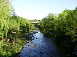
 Looking north up Etobicoke Creek from Lake Shore Boulevard | |
| Etymology | from the Mississauga word wah-do-be-kang (wadoopikaang) |
| Location | |
| Country | Canada |
| Province | Ontario |
| Region | Greater Toronto Area |
| Municipalities |
|
| Physical characteristics | |
| Source | |
| • location | Caledon, Regional Municipality of Peel |
| • coordinates | 43°47′19″N 79°53′39″W / 43.78861°N 79.89417°W |
| • elevation | 300 m (980 ft) |
| Mouth | Lake Ontario |
• location | Marie Curtis Park, Toronto |
• coordinates | 43°35′05″N 79°32′28″W / 43.58472°N 79.54111°W |
• elevation | 74 m (243 ft) |
| Length | 61 km (38 mi) |
| Basin size | 211 km2 (81 sq mi) |
| Discharge | |
| • average | 0.5 m3/s (18 cu ft/s) |
| Basin features | |
| Tributaries | |
| • left | Spring Creek, Little Etobicoke Creek |
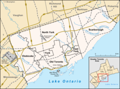
Etobicoke Creek /ɛˈtoʊbɪkoʊ/ is a river in the Greater Toronto Area of Ontario, Canada.[1] It is a tributary of Lake Ontario and runs from Caledon to southern Etobicoke, part of the City of Toronto. The creek is within the jurisdiction of the Toronto and Region Conservation Authority.
- ^ "Etobicoke Creek". Geographical Names Data Base. Natural Resources Canada. Retrieved 2012-03-15.
