Eyota | |
|---|---|
 | |
 Location of Eyota, Minnesota | |
| Coordinates: 43°59′20″N 92°13′50″W / 43.98889°N 92.23056°W | |
| Country | United States |
| State | Minnesota |
| County | Olmsted |
| Area | |
| • Total | 1.69 sq mi (4.37 km2) |
| • Land | 1.69 sq mi (4.37 km2) |
| • Water | 0.00 sq mi (0.00 km2) |
| Elevation | 1,253 ft (382 m) |
| Population (2020) | |
| • Total | 2,006 |
| • Density | 1,188.39/sq mi (458.78/km2) |
| Time zone | UTC-6 (Central (CST)) |
| • Summer (DST) | UTC-5 (CDT) |
| ZIP code | 55934 |
| Area code | 507 |
| FIPS code | 27-20114[3] |
| GNIS feature ID | 2394722[2] |

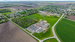
Eyota (/iˈjoʊtə/ ee-YOH-tə)[4] is a city in Olmsted County, Minnesota, United States. The population was 1,977 at the 2010 census.[5]
- ^ "2020 U.S. Gazetteer Files". United States Census Bureau. Retrieved July 24, 2022.
- ^ a b U.S. Geological Survey Geographic Names Information System: Eyota, Minnesota
- ^ "U.S. Census website". United States Census Bureau. Retrieved January 31, 2008.
- ^ "Minnesota Pronunciation Guide". Associated Press. Archived from the original on July 22, 2011. Retrieved July 4, 2011.
- ^ "2010 Census Redistricting Data (Public Law 94-171) Summary File". American FactFinder. United States Census Bureau. Retrieved April 27, 2011.[dead link]