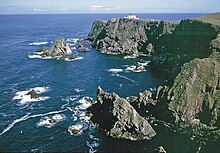
| Old Norse name | Friðarøy[1]/Friðarey[2] |
|---|---|
| Meaning of name | "fair island" or possibly "far-off isle"[1] or "sheep isle".[3] The Norse form Friðarey means literally "calm/peaceful isle" or "island (ey) of tranquility (frið(u)r)".[4] |
 Fair Isle viewed from the west | |
| Location | |
| OS grid reference | HZ209717 |
| Coordinates | 59°32′30″N 1°37′21″W / 59.54167°N 1.62250°W |
| Physical geography | |
| Island group | Shetland |
| Area | 768 ha (1,900 acres) |
| Area rank | 61 [5] |
| Highest elevation | Ward Hill 217 m (712 ft) |
| Administration | |
| Council area | Shetland Islands Council |
| Country | Scotland |
| Sovereign state | United Kingdom |
| Demographics | |
| Population | 65[6] |
| Population rank | 51 [5] |
| Population density | 7.16/km2 (18.5/sq mi) |
| Largest settlement | Stonybreck |
| References | [1][7] |
| Fair Isle North Lighthouse Skroo | |
 The view eastwards towards the Fair Isle North Lighthouse | |
| Coordinates | 59°33′08″N 1°36′34″W / 59.552142°N 1.609519°W |
| Constructed | 1892 |
| Designed by | David Alan Stevenson, Charles Alexander Stevenson |
| Construction | masonry tower |
| Automated | 1983 |
| Height | 14 m (46 ft) |
| Shape | cylindrical tower with balcony and lantern |
| Markings | white tower, black lantern, ochre trim |
| Operator | Northern Lighthouse Board[8][9] |
| Heritage | category B listed building |
| Fog signal | 3 blasts every 45 s |
| First lit | 1 November 1892 |
| Focal height | 80 m (260 ft) |
| Lens | hyperradiant Fresnel lens |
| Light source | engine generator |
| Intensity | 204,000 cd |
| Range | 22 nmi (41 km) |
| Characteristic | Fl (2) W 30s. |
| Fair Isle South Lighthouse Skadden | |
 | |
| Coordinates | 59°30′50″N 1°39′09″W / 59.513906°N 1.652611°W |
| Constructed | 1892 |
| Designed by | David Alan Stevenson, Charles Alexander Stevenson |
| Construction | masonry tower |
| Automated | 1998 |
| Height | 26 m (85 ft) |
| Shape | cylindrical tower with balcony and lantern |
| Markings | white tower, black lantern, ochre trim |
| Operator | Northern Lighthouse Board[8][10] |
| Heritage | category B listed building |
| Fog signal | 2 blasts every 60 s |
| Focal height | 32 m (105 ft) |
| Light source |
|
| Range | 22 nmi (41 km) |
| Characteristic | Fl(4) W 30s, Fl(2) W 30s |
Fair Isle (/ˈfɛər aɪl/ FAIR eyel; Old Norse: Friðarey; Scottish Gaelic: Fara), sometimes Fairisle, is the southernmost Shetland island, situated roughly 38 kilometres (20+1⁄2 nautical miles) from the Shetland Mainland and about 43 kilometres (23 nautical miles) from North Ronaldsay (the most northerly island of Orkney).[11]
The entire archipelago lies off the northernmost coast of Scotland, in the North Sea. As the most remote inhabited island in the United Kingdom (and among the most northerly settlements in Great Britain),[12] Fair Isle is known for its wild bird observatory, interesting historic shipwrecks, Scottish and Shetland-style traditional music, and its traditional style of knitting. The island has been owned by the National Trust for Scotland since 1954.
- ^ a b c Haswell-Smith, Hamish (2004). The Scottish Islands. Edinburgh: Canongate. ISBN 978-1-84195-454-7.
- ^ Anderson, Joseph (ed.) (1873) The Orkneyinga Saga. Translated by Jón A. Hjaltalin & Gilbert Goudie. Edinburgh. Edmonston and Douglas. The Internet Archive. Retrieved 26 August 2013.
- ^ Mac an Tàilleir, Iain (2003) Ainmean-àite/Placenames. (pdf) Pàrlamaid na h-Alba. Retrieved 26 August 2012.
- ^ The form friðar is the genitive singular.
- ^ a b Area and population ranks: there are c. 300 islands over 20 ha in extent and 93 permanently inhabited islands were listed in the 2011 census.
- ^ "Tiny Scots island with population of just 65 self-isolating in bid to beat coronavirus". Daily Record. 31 March 2020. Archived from the original on 4 April 2020. Retrieved 1 November 2020.
- ^ Ordnance Survey: Landranger map sheet 4 Shetland (South Mainland) (Map). Ordnance Survey. 2014. ISBN 9780319228104.
- ^ a b Rowlett, Russ. "Lighthouses of Scotland: Shetland". The Lighthouse Directory. University of North Carolina at Chapel Hill. Retrieved 14 July 2016.
- ^ Fair Isle North Archived 5 March 2016 at the Wayback Machine Northern Lighthouse Board. Retrieved 28 May 2016
- ^ "Fair Isle South". Northern Lighthouse Board. Archived from the original on 25 June 2016. Retrieved 14 July 2016.
- ^ "Fair Isle - Shetland.org". www.Shetland.org/visit. NB Communication; Promote Shetland.
- ^ Crane, Nicholas (18 February 2016). "Britain's 10 best islands". The Daily Telegraph. Archived from the original on 1 January 2016. Retrieved 14 July 2016.
