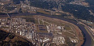
Fairfax Municipal Airport | |
|---|---|
 The remaining runway sections of the airport are along the Missouri River (right) and on the north and east of the General Motors Fairfax Assembly Plant (right of center).
 | |
| Summary | |
| Airport type | defunct |
| In use | 1921–85 |
| Coordinates | 39°08′53″N 094°35′59″W / 39.14806°N 94.59972°W |
| Map | |
Located mostly within Kansas, the Fairfax airport was north of the Kansas City Downtown Airport in Missouri. | |
 | |
Fairfax Municipal Airport (known as Fairfax Field during World War II) was a Kansas City, Kansas airfield from 1921 that was used during 1935–1949 by the military. Federal land adjacent to the airfield included a WWII B-25 Mitchell plant and modification center and a Military Air Transport terminal. After being used as a Cold War-era Air Force Base, it was used for airliner servicing by TWA and for automobile and jet fighter aircraft production by General Motors, which built a 1985 Fairfax Plant over runways when the municipal airport closed.
- ^ title tbd (aeronautical chart) (Map). available at the National Airline History Museum, Kansas City (partially online at Airfields-Freeman.com). 1946. Retrieved 2013-07-14.
- ^ Cite error: The named reference
gniswas invoked but never defined (see the help page).
