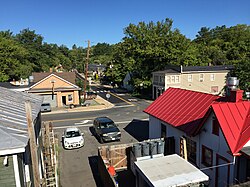
Falmouth, Virginia | |
|---|---|
Census-designated place (CDP) | |
 Central Falmouth, as seen from US 1 and US 17 Bus | |
 Location in Stafford County and the state of Virginia. | |
| Coordinates: 38°19′54″N 77°27′41″W / 38.33167°N 77.46139°W | |
| Country | United States |
| State | Virginia |
| County | Stafford |
| Area | |
• Total | 3.2 sq mi (8.4 km2) |
| • Land | 3.1 sq mi (8.1 km2) |
| • Water | 0.1 sq mi (0.3 km2) |
| Elevation | 56 ft (17 m) |
| Population | |
• Total | 4,956 |
| • Density | 1,500/sq mi (590/km2) |
| Time zone | UTC−5 (Eastern (EST)) |
| • Summer (DST) | UTC−4 (EDT) |
| Area code | 540 |
| FIPS code | 51-27264[2] |
| GNIS feature ID | 1494919[3] |
Falmouth is a census-designated place (CDP) in Stafford County, Virginia, United States. Situated on the north bank of the Rappahannock River at the falls, the community is north of and opposite the city of Fredericksburg. Recognized by the U.S. Census Bureau as a census-designated place (CDP), Falmouth's population was 4,956 as of the 2020 census.
- ^ "Profile of General Population and Housing Characteristics: 2020 Demographic Profile Data (DP-1): Falmouth CDP, Virginia". United States Census Bureau. Retrieved March 20, 2024.
- ^ "U.S. Census website". United States Census Bureau. Retrieved January 31, 2008.
- ^ "US Board on Geographic Names". United States Geological Survey. October 25, 2007. Retrieved January 31, 2008.