| False Creek | |
|---|---|
| Faux ruisseau (French) | |
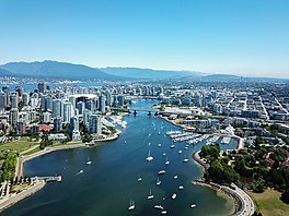
 False Creek from the air | |
| Location | Vancouver, British Columbia, Canada |
| Coordinates | 49°16′12″N 123°07′44″W / 49.27000°N 123.12889°W |
| Type | Inlet |
| Etymology | Named by George Henry Richards |
| Part of | English Bay |
| Islands | Granville Island |
| References | [1] |

False Creek (French: Faux ruisseau) is a short narrow inlet in the heart of Vancouver, separating the Downtown and West End neighbourhoods from the rest of the city. It is one of the four main bodies of water bordering Vancouver, along with English Bay (of which it is an inland extension), Burrard Inlet, and the Fraser River. Granville Island is located within the inlet.
George Henry Richards named False Creek during his hydrographic survey of 1856-1863. While travelling along the south side of the Burrard Inlet, Richards thought he was traversing a creek; upon discovering his error, he gave the inlet its current name.[2]
The inlet opens into the English Bay to its northwest, and is surrounded by the Downtown and West End neighbourhoods in the north, Strathcona in the east, and Mount Pleasant, Fairview and Kitsilano in the south. Science World is located at its easternmost end, along with BC Place Stadium and the Georgia Viaduct. Proceeding east to west, it is crossed by the Cambie, Granville, and Burrard bridges. The Canada Line rapid transit tunnel crosses underneath False Creek just west of the Cambie Bridge. In 1986, it was the location of the Expo 86 World's Fair.
False Creek South is a neighbourhood that runs along south shore roughly between the Granville and Cambie bridges. Further east, Southeast False Creek (Olympic Village) runs roughly from Cambie Street to Main Street.
- ^ "Vancouver Then and Now: False Creek (PHOTOS) | News". dailyhive.com. 1 September 2016. Retrieved 5 April 2023.
- ^ "Why False Creek is "False"". Granville Island. 2017-02-24. Retrieved 2019-08-24.

