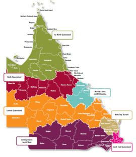
| Far North Queensland Queensland | |||||||||||||||
|---|---|---|---|---|---|---|---|---|---|---|---|---|---|---|---|
 Queensland regions | |||||||||||||||
| Population | 280,638 (2010 est.)[1] | ||||||||||||||
| • Density | 0.7370696/km2 (1.909002/sq mi) | ||||||||||||||
| Area | 380,748.3 km2 (147,007.7 sq mi) | ||||||||||||||
| LGA(s) | Aurukun, Burke, Cairns, Carpentaria, Cassowary Coast, Cook, Croydon, Doomadgee, Douglas, Etheridge, Hope Vale, Kowanyama, Lockhart River, Mapoon, Mareeba, Mornington, Napranum, Northern Peninsula Area, Pormpuraaw, Tablelands, Torres Strait Islands (not autonomous), Torres Strait Islands (autonomous), Weipa, Wujal Wujal, Yarrabah | ||||||||||||||
| State electorate(s) | Electoral district of Barron River, Electoral district of Cairns, Electoral district of Cook, Electoral district of Dalrymple, Electoral district of Hinchinbrook, Electoral district of Mulgrave | ||||||||||||||
| Federal division(s) | |||||||||||||||
| |||||||||||||||
Far North Queensland (FNQ) is the northernmost part of the Australian state of Queensland. Its largest city is Cairns and it is dominated geographically by Cape York Peninsula, which stretches north to the Torres Strait, and west to the Gulf Country. The waters of Torres Strait include the only international border in the area contiguous with the Australian mainland, between Australia and Papua New Guinea.
The region is home to three World Heritage Sites, the Great Barrier Reef, the Wet Tropics of Queensland and Riversleigh, Australia's largest fossil mammal site. Far North Queensland lays claim to over 70 national parks, including Mount Bartle Frere; with a peak of 1,622 metres (5,322 ft) it is the highest peak in both Northern Australia and Queensland.
The Far North region is the only region of Australia that is the indigenous country of both Aboriginal Australians and Torres Strait Islanders.
Far North Queensland supports a significant agricultural sector, a number of significant mines and is home to Queensland's largest wind farm, the Windy Hill Wind Farm.