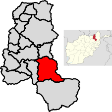
Farkhar District | |
|---|---|
 Location of Farkhar in Takhar Province | |
| Coordinates: 36°34′12″N 69°51′25″E / 36.57°N 69.857°E | |
| Country | |
| Province | Takhar |
| Government | |
| • Governor | Abdul Rashad Asfeia |
| Area | |
| • District | 1,214 km2 (469 sq mi) |
| Population (2019)[3] | |
| • District | 52,117 |
| • Density | 43/km2 (110/sq mi) |
| • Urban | 3,023 |
| • Rural | 49,094 |
| Ethnicity | |
| Time zone | UTC+4:30 (AFT) |
| Post code | 3752 [4] |
Farkhar District is a district in Takhar Province of Afghanistan. It is located southeast of Taloqan. The Khanabad River flows inside this valley. Around 99% of the people in Farkhar speak Dari. Farkhar has about 50,000 people and 75 villages.
- ^ Hedayatullah (11 September 2020). "Development projects in Takhar improve access to public services". Salaam Times. Retrieved 6 October 2020.
- ^ "Summary of the District Development Plan: Farkhar District" (PDF). mrrd-nabdp.org. Archived from the original on 1 February 2014. Retrieved 19 July 2020.
{{cite web}}: CS1 maint: unfit URL (link) - ^ "Estimated Population of Afghanistan 19-20" (PDF). nsia.gov.af. p. 29. Archived from the original (PDF) on 9 June 2020. Retrieved 5 September 2020.
- ^ "Farkhar, Afghanistan Postal Codes". worldpostalcode.com. Retrieved 19 July 2020.