| Farm River (Alternately, East Haven River among many other names) | |
|---|---|
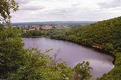
 Pistapaug Pond, one of the sources of the Farm River Beginning and end of Farm River in Connecticut | |
 | |
| Location | |
| Country | United States |
| State | Connecticut |
| County | New Haven |
| Towns | East Haven, Branford, North Branford |
| Physical characteristics | |
| Source | |
| • location | North Branford, Connecticut, United States |
| • coordinates | (41°25′23″N 72°44′16″W / 41.4231531°N 72.7378745°W) [1] |
| • elevation | 345 ft (105 m) |
| Mouth | |
• location | Long Island Sound, New Haven County, Connecticut, United States |
• coordinates | (41°14′51″N 72°51′33″W / 41.2475970°N 72.8592667°W) [1] |
• elevation | 0 ft (0 m) |
| Length | 16.5 mi (26.6 km) |
Farm River is a south-flowing river located entirely within the U.S. state of Connecticut. Because it begins as freshwater in its northern reaches and flows into tidal salt water at Long Island Sound, Farm River is by definition an estuary.[2] The river is 16.5 miles (26.6 km) long.[3]
- ^ a b "Farm River". Geographic Names Information System. United States Geological Survey, United States Department of the Interior.
- ^ Cite error: The named reference
DEEP2was invoked but never defined (see the help page). - ^ Cite error: The named reference
DEEPwas invoked but never defined (see the help page).
