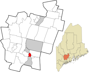
Farmingdale, Maine | |
|---|---|
 Location in Kennebec County and the state of Maine | |
| Coordinates: 44°15′15″N 69°46′42″W / 44.25417°N 69.77833°W | |
| Country | United States |
| State | Maine |
| County | Kennebec |
| Town | Farmingdale |
| Area | |
| • Total | 2.58 sq mi (6.69 km2) |
| • Land | 2.38 sq mi (6.16 km2) |
| • Water | 0.20 sq mi (0.53 km2) |
| Elevation | 52 ft (16 m) |
| Population (2020) | |
| • Total | 2,000 |
| • Density | 841.40/sq mi (324.87/km2) |
| Time zone | UTC-5 (Eastern (EST)) |
| • Summer (DST) | UTC-4 (EDT) |
| ZIP code | 04344 |
| Area code | 207 |
| FIPS code | 23-24635 |
| GNIS feature ID | 0566053 |
Farmingdale is a census-designated place (CDP) in the town of Farmingdale in Kennebec County, Maine, United States. The population was 1,970 at the 2010 census,[2] out of 2,956 in the entire town.
- ^ "2020 U.S. Gazetteer Files". United States Census Bureau. Retrieved April 8, 2022.
- ^ "Geographic Identifiers: 2010 Census Summary File 1 (G001), Farmingdale CDP, Maine". American FactFinder. U.S. Census Bureau. Archived from the original on February 13, 2020. Retrieved March 8, 2019.