Farmington, Connecticut | |
|---|---|
 Aerial view of the Farmington Historic District | |
| Motto(s): "Respecting History, Planning The Future"[1] | |
| Coordinates: 41°43′40″N 72°50′25″W / 41.72778°N 72.84028°W | |
| Country | |
| U.S. state | |
| County | Hartford |
| Region | Capitol Region |
| Settled | June 1640 |
| Incorporated | December 1645 |
| Consolidated | 1947 |
| Communities | Farmington Bensted Corner East Farmington Heights Farmington Station Oakland Gardens River Glen Unionville |
| Government | |
| • Type | Council-manager |
| • Town Council | C.J. Thomas (R), Chm Rafeena Bacchus Lee (D) Joseph Capidoferro (R) Edward Giannaros (D) Johnny Carrier (R) Brian Connolly (D) Keith Vibert (R) |
| Area | |
| • Total | 28.8 sq mi (74.5 km2) |
| • Land | 28.0 sq mi (72.6 km2) |
| • Water | 0.8 sq mi (2.0 km2) |
| Elevation | 161 ft (49 m) |
| Population (2020) | |
| • Total | 26,712 |
| • Density | 930/sq mi (360/km2) |
| Time zone | UTC−5 (Eastern) |
| • Summer (DST) | UTC−4 (Eastern) |
| ZIP Codes | 06032, 06085 |
| Area code(s) | 860/959 |
| FIPS code | 09-27600 |
| GNIS feature ID | 0213430 |
| Interstates | |
| U.S. Highways | |
| State Routes | |
| Website | www |
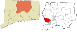
Farmington is a town in Hartford County in the Farmington Valley area of central Connecticut in the United States. The town is part of the Capitol Planning Region. The population was 26,712 at the 2020 census.[2] It sits 10 miles west of Hartford at the hub of major I-84 interchanges, 20 miles south of Bradley International Airport and two hours by car from New York City and Boston. It has been home to the world headquarters of several large corporations including Otis Elevator Company, United Technologies, and Carvel. The northwestern section of Farmington is a suburban neighborhood called Unionville.
- ^ "Town of Farmington Connecticut". Town of Farmington Connecticut. Retrieved September 22, 2012.
- ^ "Census - Geography Profile: Farmington town, Hartford County, Connecticut". United States Census Bureau. Retrieved December 15, 2021.


