Farmington, Missouri | |
|---|---|
 Farmington, Missouri City hall, May 2019 | |
| Motto(s): Tradition and Progress | |
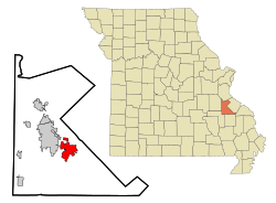
 Location of Farmington, Missouri | |
Location within the contiguous United States of America | |
| Coordinates: 37°46′55″N 90°25′20″W / 37.78194°N 90.42222°W | |
| Country | |
| State | |
| County | St. Francois |
| Government | |
| • Type | City council |
| • Mayor | Larry Forsythe |
| Area | |
| • Total | 9.55 sq mi (24.74 km2) |
| • Land | 9.49 sq mi (24.59 km2) |
| • Water | 0.06 sq mi (0.15 km2) |
| Elevation | 948 ft (289 m) |
| Population (2020) | |
| • Total | 18,217 |
| • Density | 1,918.79/sq mi (740.85/km2) |
| Time zone | UTC-6 (Central (CST)) |
| • Summer (DST) | UTC-5 (CDT) |
| Zip Code | 63640 |
| Area code | 573 |
| FIPS code | 29-23752 |
| GNIS feature ID | 2394749[2] |
| Website | http://farmington-mo.gov |
Farmington is a city in St. Francois County located about 75 miles (121 km) southwest of St. Louis in the Lead Belt region in Missouri. As of the 2020 census, the population was 18,217. It is the county seat of St. Francois County.[3] Farmington was established in 1822 as Murphy's Settlement, named for William Murphy of Kentucky, who first visited the site in 1798. When St. Francois County was organized, the town was briefly called St. Francois Court House and later renamed to Farmington.[4]
- ^ "ArcGIS REST Services Directory". United States Census Bureau. Retrieved August 28, 2022.
- ^ a b U.S. Geological Survey Geographic Names Information System: Farmington, Missouri
- ^ "Find a County". National Association of Counties. Archived from the original on May 31, 2011. Retrieved June 7, 2011.
- ^ Earngey, Bill (1995). Missouri Roadsides: The Traveler's Companion. Columbia, MO: University of Missouri Press. p. 87. ISBN 978-0-8262-1021-0.

