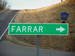
Farrar, Missouri | |
|---|---|
 Farrar, Missouri, road sign | |
 Location of Farrar, Missouri | |
| Coordinates: 37°42′08″N 89°41′19″W / 37.70222°N 89.68861°W | |
| Country | United States |
| State | Missouri |
| County | Perry |
| Township | Salem |
| Area | |
| • Total | 1.26 sq mi (3.26 km2) |
| • Land | 1.26 sq mi (3.26 km2) |
| • Water | 0 sq mi (0 km2) |
| Elevation | 476 ft (145 m) |
| Population (2000) | |
| • Total | 65 [1] |
| • Estimate (2010) | 66 |
| • Density | 51.56/sq mi (302.9/km2) |
| Time zone | UTC-6 (Central (CST)) |
| • Summer (DST) | UTC-5 (CDT) |
| ZIP code | 63746 |
| Area code | 573 |
| FIPS code | 29-29157 [4] |
| GNIS feature ID | 717857[3] |
Farrar /ˈfɑːr/ is an unincorporated community in Salem Township in eastern Perry County, Missouri, United States. It is located eight miles east of Perryville, ninety miles south of Saint Louis and 3.7 miles from the Mississippi River.
- ^ Hometown Locator: Missouri http://missouri.hometownlocator.com/mo/perry/farrar.cfm
- ^ Hometown Locator: Missouri http://www.hometownlocator.com/maps/accessproblem.cfm
- ^ a b U.S. Geological Survey Geographic Names Information System: Farrar, Missouri
- ^ "US Zip code Farrar - Missouri".