| Feltham | |
|---|---|
| Town | |
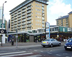
 High Street, Feltham town centre | |
Location within Greater London | |
| Area | 6.56 km2 (2.53 sq mi) |
| Population | 63,368 2011 Census[1] |
| • Density | 9,660/km2 (25,000/sq mi) |
| OS grid reference | TQ105735 |
| London borough | |
| Ceremonial county | Greater London |
| Shire county | |
| Region | |
| Country | England |
| Sovereign state | United Kingdom |
| Post town | FELTHAM |
| Postcode district | TW13, TW14 |
| Dialling code | 020 |
| Police | Metropolitan |
| Fire | London |
| Ambulance | London |
| UK Parliament | |
| London Assembly | |
Feltham (/ˈfɛltəm/) is a town in West London, England, 13 miles (21 km) from Charing Cross. Historically part of Middlesex, it became part of the London Borough of Hounslow in 1965. The parliamentary constituency of Feltham and Heston has been held by Labour Party MPs since 1992. In 2011, the population of the combined census area of Feltham, Bedfont and Hanworth was 63,368.
The economy of the town was largely agrarian until the early twentieth century, when it was transformed by the expansion of the London urban area. Most of the original High Street was demolished in the 1960s and 1970s. Further redevelopment in the early 2000s created the current shopping centre, which opened in 2006.
Heathrow Airport is to the north west of the town and is a major centre of employment for local residents. Feltham railway station is on the Waterloo to Reading line, between Twickenham and Staines-upon-Thames.
- ^ Feltham is made up of 5 wards in the London Borough of Hounslow: Bedfont, Feltham North, Feltham West, Hanworth, and Hanworth Park. "2011 Census Ward Population Estimates | London DataStore". Archived from the original on 22 February 2014. Retrieved 9 June 2014.
