Fengyuan
豐原區 | |
|---|---|
| Fengyuan District | |
 | |
 | |
| Coordinates: 24°15′N 120°43′E / 24.250°N 120.717°E | |
| Country | Republic of China (Taiwan) |
| Special municipality | Taichung |
| Area | |
| • Total | 41.1845 km2 (15.9014 sq mi) |
| Population (February 2023) | |
| • Total | 163,750 |
| • Density | 4,031/km2 (10,440/sq mi) |
| Time zone | UTC+8 (National Standard Time) |
| Postal code | 420 |
| Website | www |
| Fengyuan District | |||||||||||||
|---|---|---|---|---|---|---|---|---|---|---|---|---|---|
| Traditional Chinese | 豐原區 | ||||||||||||
| |||||||||||||
| Alternative Chinese name | |||||||||||||
| Traditional Chinese | 葫蘆墩 | ||||||||||||
| |||||||||||||

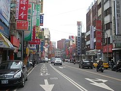
Fengyuan District (Chinese: 豐原區) is a district located in north-central Taichung, Taiwan on the south bank of the Dajia River. Fengyuan district is the third most populated district among former Taichung County, ranking after Dali and Taiping district. Fengyuan was recognized as Huludun in early times, meaning "gourd" in Chinese, for a gourd-shape pile of mud that was found in Fengyuan by the aborigines. The rice produced in Fengyuan is famous for its high quality and the bakery industry prospered in later decades. Because of its location of the intersection of Taiwan Railways Administration Western Trunk line and Dongshi branch line, Fengyuan quickly expanded after World War II. It soon became one of the regions with great economic and cultural development in central Taiwan. After the merger of Taichung City and Taichung County in 2010, population and economic growth slowed slightly. so recently, fengyuan faces the challenge of being marginalized .