This article needs additional citations for verification. (May 2017) |
Fernie | |
|---|---|
| The Corporation of the City of Fernie | |
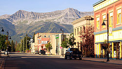
 Downtown Fernie, looking south | |
| Motto(s): "In montibus ad flumen" (Latin) "In the mountains by the river" | |
Location of Fernie in British Columbia | |
| Coordinates: 49°30′15″N 115°03′46″W / 49.50417°N 115.06278°W | |
| Country | Canada |
| Province | British Columbia |
| Region | Elk Valley/East Kootenay |
| Regional district | East Kootenay |
| Established | 1904 |
| Government | |
| • Mayor | Nic Milligan |
| • Governing body | Fernie City Council |
| • MP | Rob Morrison |
| • MLA | Tom Shypitka |
| Area | |
| • City | 13.50 km2 (5.21 sq mi) |
| Elevation | 1,010 m (3,314 ft) |
| Population (2016) | |
| • City | 5,249 Ranked 692nd |
| • Metro | 7,192 |
| Time zone | UTC-7 (Mountain Standard (MST)) |
| • Summer (DST) | UTC-6 (Mountain Daylight (MDT)) |
| Postal code span | V0B 1M(0–6) |
| Area code(s) | 250, 778, 236, 672 |
| Highways | |
| Website | fernie |

Fernie is a city in the Elk Valley area of the East Kootenay region of southeastern British Columbia, Canada, located on BC Highway 3 on the western approaches to the Crowsnest Pass through the Rocky Mountains. Founded in 1898 and incorporated as the City of Fernie in July 1904, the municipality has a population of over 5,000[1] with an additional 2,000[2] outside city limits in communities under the jurisdiction of the Regional District of East Kootenay. A substantial seasonal population swells the city during the winter months.
Fernie lies on the Elk River, along Canada's southernmost east-west transportation corridor through the Rockies that crosses the range via the Crowsnest Pass, 40 kilometres (25 miles) to the east. As the largest and longest-established community between Cranbrook and Lethbridge, Fernie serves as a minor regional centre, particularly for its fellow Elk Valley communities.


