Filippoi
Φίλιπποι | |
|---|---|
| Coordinates: 41°1′N 24°17′E / 41.017°N 24.283°E | |
| Country | Greece |
| Administrative region | East Macedonia and Thrace |
| Regional unit | Kavala |
| Municipality | Kavala |
| Area | |
| • Municipal unit | 238.8 km2 (92.2 sq mi) |
| Elevation | 78 m (256 ft) |
| Population (2021)[1] | |
| • Municipal unit | 10,133 |
| • Municipal unit density | 42/km2 (110/sq mi) |
| • Community | 796 |
| Time zone | UTC+2 (EET) |
| • Summer (DST) | UTC+3 (EEST) |
| Postal code | 640 03 |
| Area code(s) | 2510 |
| Vehicle registration | ΚΒ |

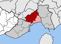
Filippoi (Greek: Φίλιπποι, Philippi), is a village and a former municipality in the Kavala regional unit, East Macedonia and Thrace, Greece built on the Via Egnatia. Since the 2011 local government reform it is part of the municipality Kavala, of which it is a municipal unit.[2] The municipal unit has an area of 238.751 km2.[3] The 2021 census reported a population of 10,133 for the municipal unit and 796 for the village.[1] The ruins of ancient Philippi are located in the municipal unit.
- ^ a b "Αποτελέσματα Απογραφής Πληθυσμού - Κατοικιών 2021, Μόνιμος Πληθυσμός κατά οικισμό" [Results of the 2021 Population - Housing Census, Permanent population by settlement] (in Greek). Hellenic Statistical Authority. 29 March 2024.
- ^ "ΦΕΚ A 87/2010, Kallikratis reform law text" (in Greek). Government Gazette.
- ^ "Population & housing census 2001 (incl. area and average elevation)" (PDF) (in Greek). National Statistical Service of Greece. Archived from the original (PDF) on 2015-09-21.

