Fisher Island, Florida | |
|---|---|
 | |
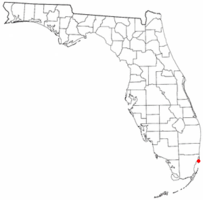
 Location of Fisher Island in Florida | |
 U.S. Census Bureau map showing CDP boundaries | |
| Coordinates: 25°45′42″N 80°8′39″W / 25.76167°N 80.14417°W | |
| Country | |
| State | |
| County | |
| Area | |
| • Total | 0.27 sq mi (0.69 km2) |
| • Land | 0.24 sq mi (0.62 km2) |
| • Water | 0.03 sq mi (0.07 km2) |
| Elevation | 10 ft (3 m) |
| Population | |
| • Total | 561 |
| • Density | 2,328/sq mi (899/km2) |
| Time zone | UTC-5 (Eastern (EST)) |
| • Summer (DST) | UTC-4 (EDT) |
| ZIP Code | 33109 (Miami Beach) |
| Area code(s) | 305, 786, 645 |
| FIPS code | 12-22375[3] |
| GNIS feature ID | 1853250[4] |
Fisher Island is a census-designated place in Miami-Dade County, Florida, United States, located on a barrier island of the same name. Since 2015, Fisher Island has the highest per capita income[5] of any place in the United States. It is located in the Miami metropolitan area of South Florida. As of the 2020 census, the population was 561.[2]
Named for automotive parts pioneer and beach real estate developer Carl G. Fisher, who once owned it,[6] Fisher Island is three miles off the shore of mainland South Florida. No road or causeway connects to the island, which is only accessible by private boat, helicopter, or ferry. Once a one-family island home of the Vanderbilts, and later several other millionaires, it was sold for development in the 1960s. The property sat vacant for well over 15 years before development began for very limited and restrictive multi-family use.
- ^ "2022 U.S. Gazetteer Files: Florida". United States Census Bureau. Retrieved January 5, 2023.
- ^ a b "P1. Race – Fisher Island CDP, Florida: 2020 DEC Redistricting Data (PL 94-171)". U.S. Census Bureau. Retrieved January 5, 2023.
- ^ "U.S. Census website". United States Census Bureau. Retrieved January 31, 2008.
- ^ "US Board on Geographic Names". United States Geological Survey. October 25, 2007. Retrieved January 31, 2008.
- ^ "This Is America's Richest Zip Code". Yahoo.com. Retrieved April 11, 2018.
- ^ "History Page | Fisher Island". Retrieved January 12, 2024.