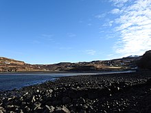
Fiskavaig
| |
|---|---|
Location within the Isle of Skye | |
| OS grid reference | NG328340 |
| Council area | |
| Country | Scotland |
| Sovereign state | United Kingdom |
| Postcode district | IV47 8 |
| Police | Scotland |
| Fire | Scottish |
| Ambulance | Scottish |
Fiskavaig or Fiscavaig (Scottish Gaelic: Fiosgabhaig) is a picturesque crofting settlement on the north-west shore of the Minginish peninsula, Isle of Skye in the Highland Council area.

The township extends westward around the coast some 2.5 miles from Ardtreck in the east, originally however Fiskavaig was a small hamlet centred on the west side of Fiskavaig Bay, (where Fiskavaig Burn enters), at which the remains of several houses can still be seen. These appear to have been inhabited up until the end of the 19th century, and the remains of a small stone pier is still evident.
An 1877 Ordnance Survey Map[1] shows several houses in this location and although unclear how many were inhabited at the time the OS Name Book notes that the name Fiskavaig: "...is applied to a hamlet of thatched houses occupied by work men in service of the Talisker farmer, the houses are one storey & have a wretched appearance On the property of McLeod of McLeod. The name is Anglicised Fiskr, a fish: vagr, a bay = Fish Bay", Norse."[2] Notably this map does not show the pier.
According to The Island Whisky Trail by Neil Wilson, Fiskavaig was originally the intended site of the nearby Talisker Distillery: "The original intended site of MacAskill's distillery is to be found 5 miles further north of the current location (Carbost) at Fiskavaig, just beyond Portnalong, but an unreliable water source forced the brothers to settle for Carbost."[3]
- ^ "View map: Inverness-shire (Isle of Skye), Sheet XXXIII (includes: Bracadale) - Ordnance Survey Six-inch 1st edition, Scotland, 1843-1882". maps.nls.uk. Retrieved 18 February 2021.
- ^ "Inverness-shire (Skye) volume 02 | ScotlandsPlaces". scotlandsplaces.gov.uk. Retrieved 18 February 2021.
- ^ Wilson, Neil. The Island Whisky Trail.
