You can help expand this article with text translated from the corresponding article in German. Click [show] for important translation instructions.
|
Flims | |
|---|---|
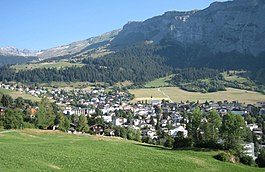
 Flims Dorf under "Flimserstein" | |
| Coordinates: 46°50′N 9°17′E / 46.833°N 9.283°E | |
| Country | Switzerland |
| Canton | Graubünden |
| District | Imboden |
| Area | |
• Total | 50.46 km2 (19.48 sq mi) |
| Elevation | 1,081 m (3,547 ft) |
| Population (31 December 2018)[2] | |
• Total | 2,834 |
| • Density | 56/km2 (150/sq mi) |
| Time zone | UTC+01:00 (Central European Time) |
| • Summer (DST) | UTC+02:00 (Central European Summer Time) |
| Postal code(s) | 7017-7019 |
| SFOS number | 3732 |
| ISO 3166 code | CH-GR |
| Surrounded by | Glarus Süd (GL), Laax, Pfäfers (SG), Sagogn, Trin, Valendas, Versam |
| Website | www SFSO statistics |
Flims (Romansh: Flem) is a municipality in the Imboden Region in the Swiss canton of Graubünden. The town of Flims is dominated by the Flimserstein which one can see from almost anywhere in the area.
Flims consists of the village of Flims (called Flims Dorf) and the hamlets of Fidaz and Scheia as well as Flims-Waldhaus, the initial birthplace of tourism in Flims, where most of the hotels were built before and after around 1900.

- ^ a b "Arealstatistik Standard - Gemeinden nach 4 Hauptbereichen". Federal Statistical Office. Retrieved 13 January 2019.
- ^ "Ständige Wohnbevölkerung nach Staatsangehörigkeitskategorie Geschlecht und Gemeinde; Provisorische Jahresergebnisse; 2018". Federal Statistical Office. 9 April 2019. Retrieved 11 April 2019.


