| Floriana Lines | |
|---|---|
Is-Swar tal-Furjana | |
| Floriana, Malta | |
 San Salvatore Bastion and Counterguard | |
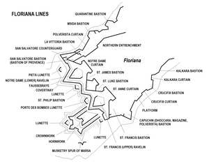
 Map of the Floriana Lines | |
| Coordinates | 35°53′26″N 14°30′8″E / 35.89056°N 14.50222°E |
| Type | Line of fortifications |
| Site information | |
| Owner | Government of Malta |
| Condition | Mostly intact |
| Site history | |
| Built | 1636–18th century |
| Built by | Order of Saint John |
| In use | 1640–20th century |
| Materials | Limestone |
| Battles/wars | Siege of Malta (1798–1800) |
The Floriana Lines (Maltese: Is-Swar tal-Furjana) are a line of fortifications in Floriana, Malta, which surround the fortifications of Valletta and form the capital city's outer defences. Construction of the lines began in 1636 and they were named after the military engineer who designed them, Pietro Paolo Floriani. The Floriana Lines were modified throughout the course of the 17th and 18th centuries, and they saw use during the French blockade of 1798–1800. Today, the fortifications are still largely intact but rather dilapidated and in need of restoration.
The Floriana Lines are considered to be among the most complicated and elaborate of the Hospitaller fortifications of Malta.[1] Since 1998, they have been on the tentative list of UNESCO World Heritage Sites, as part of the Knights' Fortifications around the Harbours of Malta.[2]
- ^ Cite error: The named reference
bastionofprovencewas invoked but never defined (see the help page). - ^ "Knights' Fortifications around the Harbours of Malta". UNESCO Tentative List. Retrieved 15 July 2015.
