Folegandros
Φολέγανδρος | |
|---|---|
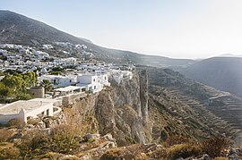
Cliffs at Chora on Folegandros | |
| Coordinates: 36°37′N 24°54′E / 36.617°N 24.900°E | |
| Country | Greece |
| Administrative region | South Aegean |
| Regional unit | Thira |
| Area | |
| • Municipality | 32.216 km2 (12.439 sq mi) |
| Highest elevation | 455 m (1,493 ft) |
| Lowest elevation | 0 m (0 ft) |
| Population (2021)[1] | |
| • Municipality | 719 |
| • Density | 22/km2 (58/sq mi) |
| • Community | 455 |
| Time zone | UTC+2 (EET) |
| • Summer (DST) | UTC+3 (EEST) |
| Postal code | 840 xx |
| Area code(s) | 22860 |
| Vehicle registration | EM |
| Website | www.folegandros.gr |
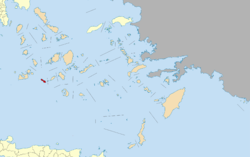
Folegandros (also Pholegandros; Greek: Φολέγανδρος) is a small Greek island in the Aegean Sea that, together with Sikinos, Ios, Anafi and Santorini, forms the southern part of the Cyclades. Its surface area is 32.216 square kilometres (12.439 sq mi)[2] and it has 719 inhabitants (2021). It has three small villages, Chora, Karavostasis, and Ano Meria, which are connected by a paved road. Folegandros is part of the Thira regional unit.[3]
- ^ "Αποτελέσματα Απογραφής Πληθυσμού - Κατοικιών 2021, Μόνιμος Πληθυσμός κατά οικισμό" [Results of the 2021 Population - Housing Census, Permanent population by settlement] (in Greek). Hellenic Statistical Authority. 29 March 2024.
- ^ "Population & housing census 2001 (incl. area and average elevation)" (PDF) (in Greek). National Statistical Service of Greece. Archived from the original (PDF) on 2015-09-21.
- ^ "ΦΕΚ A 87/2010, Kallikratis reform law text" (in Greek). Government Gazette.


