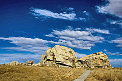
The Foothills Erratics Train is a 580 miles (930 km) long, narrow (0.62 miles (1.00 km) to 13.7 miles (22.0 km) wide), linear scatter of thousands of typically angular boulders of distinctive quartzite and pebbly quartzite that lie on the surface of a generally north-south strip of the Canadian Prairies. These boulders, which are between 1 foot (0.30 m) and 135 feet (41 m) in length, are glacial erratics that lie upon a surficial blanket of Late Wisconsin glacial till. The largest glacial erratic within the Foothills Erratics Train is Big Rock.[1][2]
The narrow strip of prairie covered by the Foothills Erratics Train extends along the eastern flanks of the Rocky Mountains of Alberta and northern Montana. The boulders of the Foothills Erratics Train consist of pink and purple Lower Cambrian shallow marine quartzite and conglomeratic quartzite, that are not native to this region of Alberta. These rocks only occur within the Gog Group that is exposed in the Tonquin Valley in the Rocky Mountains of central western Alberta. Their specific source has been identified as being near Mount Edith Cavell in Jasper National Park. Lying on prairie to the east of the Rocky Mountains, the larger glacial erratics of the Foothills Erratics Train are visible for a considerable distance across the prairie and likely served as a prominent landmark for Indigenous people.[1][2][3][4][5]
- ^ a b Stalker, A MacS (1956). The erratics train, Foothills of Alberta. Geological Survey of Canada, Bulletin no. 37, 28 p.
- ^ a b Stalker, A MacS (1975). "The big rock." In Structural geology of the foothills between Savanna Creek and Panther River, S.W. Alberta, Canada. May 23, 1975. H. J. Evers and J. E. Thorpe, eds., pp. 9-11. Calgary, Alberta, Canada: Canadian Society of Petroleum Geologists.
- ^ Jackson, L.E. Jr., Phillips, F.M., Shimamura, K., Little, E.C., 1997. Cosmogenic 36Cl dating of the Foothills erratics train, Alberta, Canada. Geology. 25:195–198.
- ^ Jackson, L.E. Jr., Phillips, F.M., Little, E.C., 1999b. Cosmogenic 36Cl dating of the maximum limit of the Laurentide Ice Sheet in southwestern Alberta. Canadian Journal of Earth Science. 36:1347–1356.
- ^ Cruden, DM, W Langenberg, and RC Paulen (2003). Geology of the Frank Slide and southwestern Alberta. Edmonton Geological Society – Geological Association of Canada annual field trip celebrating the 100th anniversary of the Frank Slide Disaster. Edmonton, Alberta: Edmonton Geological Society. 34 pp.