| Ford | |
|---|---|
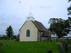
 St. Andrew by the ford | |
Location within West Sussex | |
| Area | 4.08 km2 (1.58 sq mi) [1] |
| Population | 1,690 (Civil Parish 2011)[2] |
| • Density | 414/km2 (1,070/sq mi) |
| OS grid reference | TQ000036 |
| • London | 51 miles (82 km) NNE |
| Civil parish |
|
| District | |
| Shire county | |
| Region | |
| Country | England |
| Sovereign state | United Kingdom |
| Post town | Arundel |
| Postcode district | BN18 |
| Dialling code | 01903 or 01243 |
| Police | Sussex |
| Fire | West Sussex |
| Ambulance | South East Coast |
| UK Parliament | |
Ford is a village and civil parish in the Arun District of West Sussex, England. It is centred 2 miles (3 km) south by south-west of Arundel and west of Worthing. The civil parish very gently slopes to the east, where it has the public track alongside the River Arun and the land is low but well-drained at 2 to 7 metres above Ordnance Datum (sea level).
The parish includes HM Prison Ford, otherwise known as Ford Open Prison centred on the site of two former government installations, the RAF Ford Battle of Britain airfield and the Royal Naval Air Station HMS Peregrine. These have a small commemorative garden, Rollaston Park, along the road of the same name.
Ford railway station is on the West Coastway Line which has the listed building and pub next to it on semi-rural Arundel Road. Some larger units of Rudford Industrial estate are in the south of the parish.
- ^ "2001 Census: West Sussex – Population by Parish" (PDF). West Sussex County Council. Archived from the original (.pdf) on 8 June 2011. Retrieved 26 March 2009.
- ^ Key Statistics; Quick Statistics: Population Density Archived 11 February 2003 at the Wayback Machine United Kingdom Census 2011 Office for National Statistics Retrieved 10 May 2014
