Forssa | |
|---|---|
Town | |
| Forssan kaupunki Forssa stad | |
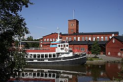
 By the River Loimijoki | |
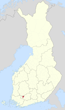
 Location of Forssa in Finland | |
| Coordinates: 60°49′N 023°37.5′E / 60.817°N 23.6250°E | |
| Country | |
| Region | Kanta-Häme |
| Sub-region | Forssa sub-region |
| Charter | 1923 |
| Town privileges | 1964 |
| Government | |
| • Town manager | Jari Kesäniemi[1] |
| Area (2018-01-01)[2] | |
• Total | 253.38 km2 (97.83 sq mi) |
| • Land | 248.84 km2 (96.08 sq mi) |
| • Water | 4.61 km2 (1.78 sq mi) |
| • Rank | 246th largest in Finland |
| Population (2024-08-31)[3] | |
• Total | 16,450 |
| • Rank | 67th largest in Finland |
| • Density | 66.11/km2 (171.2/sq mi) |
| Population by native language | |
| • Finnish | 91.8% (official) |
| • Swedish | 0.3% |
| • Others | 7.9% |
| Population by age | |
| • 0 to 14 | 12% |
| • 15 to 64 | 56.5% |
| • 65 or older | 31.5% |
| Time zone | UTC+02:00 (EET) |
| • Summer (DST) | UTC+03:00 (EEST) |
| Website | www |
Forssa is a town and municipality of Finland. It is located almost in the centre of a triangle defined by the three largest major cities in Finland (Helsinki, Turku and Tampere), in the Tavastia Proper region, and which is crossed by Highway 2 between Pori and Helsinki and Highway 10 between Turku and Hämeenlinna. The town has a population of 16,450 (31 August 2024)[3] and covers an area of 253.38 square kilometres (97.83 sq mi) of which 4.61 km2 (1.78 sq mi) is water.[2] The population density is 66.11 inhabitants per square kilometre (171.2/sq mi). Only a little part of the surface area of Forssa is water, but the river Loimijoki forms an important element in the cityscape, with the city being located at its starting point. Other notable water areas in Forssa include the lake Kaukjärvi and the lake Koijärvi, known as the birthplace of the Green League.[6]
The municipality is unilingually Finnish. However, the name Forssa comes from the Swedish word "fors", meaning rapids.[7]
Forssa is the central locality of the Forssa sub-region. The city is bordered with Jokioinen to the west, Tammela to the east and south and Humppila and Urjala to the north. As well as Forssa, the Forssa sub-region includes Jokioinen, Tammela, Humppila and Ypäjä.[8] Forssa is the smallest of the three cities in Tavastia Proper, with a population of about 16,500, and in terms of population Forssa is the 67th largest municipality in Finland.[9] The population in Forssa has concentrated on the Forssa central conurbation in the southern part of the municipality, which also spreads over to the municipalities of Jokioinen and Tammela. The area of the former municipality of Koijärvi in the northern part of the city is a sparsely populated rural area.
Forssa grew and developed in the 19th century when the textile industry grew. In the 20th century the city barely grew at all between the two World wars. A new growth phase began in the 1960s, sped by construction industry. The population of Forssa was as its highest in the middle 1980s when the city had a bit over 20 thousand inhabitants for two years. The growth of the city since stopped as the industry started diminishing. By 1994 the population had decreased by a few hundred people, but after that the decrease in population grew. By late 2005 Forssa had lost over two thousand people compared to its highest point. In 2008 the population of Forssa increased for the first time since 1993. After 2010 population has again decreased, with the population in 2016 being about 17,300.[10] Today the food industry is a notable employer.
The location of Forssa, in the middle of the triangle formed by the cities of Helsinki, Turku and Tampere, is sometimes seen as ideal, as commute trips to the largest cities in the country are fast. The distance to Helsinki is 110 kilometres, the distance to Tampere is 87 kilometres and the distance to Turku is 88 kilometres.[11]
- ^ "Forssa sai uuden kaupunginjohtajan Koskelta: "Yhdessä olemme enemmän"". Yle Uutiset (in Finnish). 20 December 2016. Retrieved 28 October 2020.
- ^ a b "Area of Finnish Municipalities 1.1.2018" (PDF). National Land Survey of Finland. Retrieved 30 January 2018.
- ^ a b c "Finland's preliminary population figure was 5,625,011 at the end of August 2024". Population structure. Statistics Finland. 24 September 2024. ISSN 1797-5395. Retrieved 25 September 2024.
- ^ "Population according to age (1-year) and sex by area and the regional division of each statistical reference year, 2003–2020". StatFin. Statistics Finland. Retrieved 2 May 2021.
- ^ a b "Luettelo kuntien ja seurakuntien tuloveroprosenteista vuonna 2023". Tax Administration of Finland. 14 November 2022. Retrieved 7 May 2023.
- ^ Muistojemme Koijärvi elää, Vihreä lanka 5 March 2012. Accessed on 17 August 2012.
- ^ "Forssa - Häme-Wiki". Archived from the original on 1 November 2014. Retrieved 7 January 2017.
- ^ Luokitukset - Kunnat 2012 / Seutukunnat 2012 - Luokitusavain, Statistics Finland 2012. Accessed on 17 August 2012.
- ^ Väestörakenteen ennakkotiedot alueittain, 2022M01*-2022M06*, Statistics Finland 30 June 2022. Accessed on 11 August 2022.
- ^ Väestö iän (1-v.) ja sukupuolen mukaan alueittain 1972 - 2016 Archived 28 December 2017 at the Wayback Machine, Statistics Finland. Accessed on 28 December 2017.
- ^ Paikkakuntien välimatkoja Suomessa Archived 20 April 2010 at the Wayback Machine, Finnish Transport Bureau. Accessed on 17 August 2012.
