| Fort Andrew/Gurnet Fort | |
|---|---|
| Gurnet Point, Plymouth, Massachusetts | |
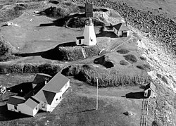
 Fort Andrew's earthworks and Plymouth Light | |
| Coordinates | 42°00′19″N 70°35′58″W / 42.005172°N 70.599517°W |
| Type | Coastal defense |
| Site information | |
| Owner | private |
| Controlled by | US Coast Guard |
| Open to the public | seasonal with lighthouse |
| Condition | earthworks remain |
| Site history | |
| Built | 1776 |
| In use | 1776–1869 |
| Materials | earthworks |
| Battles/wars | American Revolutionary War War of 1812 American Civil War |
Fort Andrew is a former fort built as Gurnet Fort in 1776 for the American Revolutionary War on Gurnet Point in Plymouth, Massachusetts. It became a federal fort and was rebuilt in 1808, and again in 1863 during the Civil War when it received its current name. It is named for John A. Andrew, governor of Massachusetts 1861–1866.[1] In 1863 Fort Standish was built nearby on Saquish Head. After the war, the federal government declared Fort Andrew an inactive military reservation in 1869. The reservation was sold in 1926 and mostly became private property, except for the US Coast Guard light station. A World War II fire control tower was built on the parapet of the old fort. Plymouth (Gurnet Point) lighthouse is also on Gurnet Point, and was moved inside the fort's earthworks to protect it from beach erosion in 1997–1998.[2]
- ^ Roberts, p. 393
- ^ "Massachusetts - Fort Andrew and Gurnet Fort". American Forts Network. Retrieved 16 June 2020.

