| Fort Atkinson State Historical Park | |
|---|---|
 Powder magazine at Fort Atkinson | |
| Location | Fort Calhoun, Nebraska, United States |
| Coordinates | 41°27′18″N 96°00′51″W / 41.45500°N 96.01417°W[1] |
| Area | 154.36 acres (62.47 ha)[2] |
| Elevation | 1,073 ft (327 m)[1] |
| Designation | Nebraska state historical park |
| Established | 1963 |
| Visitors | 40280 (in 2017)[3] |
| Administrator | Nebraska Game and Parks Commission |
| Website | Fort Atkinson State Historical Park |
Fort Atkinson | |
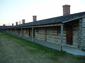
 Detail of (reconstructed) west rampart barracks | |
| Built | 1819 |
| NRHP reference No. | 66000454 |
| Significant dates | |
| Added to NRHP | October 15, 1966 |
| Designated NHL | July 4, 1961 |
Fort Atkinson was the first United States Army post to be established west of the Missouri River in the unorganized region of the Louisiana Purchase of the United States. Located just east of present-day Fort Calhoun, Nebraska, the fort was erected in 1819 and abandoned in 1827. The site is now known as Fort Atkinson State Historical Park and is a National Historic Landmark. A replica fort was constructed by the state at the site during the 1980s–1990s.[4]
The post, which included soldiers, traders, trappers, and other frontier people, has been credited by the Nebraska State Legislature as the first town in Nebraska. Founded almost 30 years before the creation of the Nebraska Territory, Fort Atkinson had more than 1,000 residents. It included a brickyard, lime kiln, stone quarry, grist mill, saw mill, and cooper shop.[5]
- ^ a b "Fort Atkinson State Historical Park". Geographic Names Information System. United States Geological Survey, United States Department of the Interior.
- ^ Cite error: The named reference
ngpc2was invoked but never defined (see the help page). - ^ Cite error: The named reference
tourismwas invoked but never defined (see the help page). - ^ Cite error: The named reference
ngpcwas invoked but never defined (see the help page). - ^ (1912) Bulletin. Issues 2. Nebraska State Legislature. p. 7.

