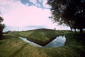
| Fort Caroline National Memorial | |
|---|---|
 | |
 | |
| Location | Arlington, Jacksonville, Florida, United States |
| Coordinates | 30°23′13″N 81°30′2″W / 30.38694°N 81.50056°W |
| Area | 138.39 acres (56.00 ha) |
| Established | 16 January 1953 |
| Visitors | 145,736 (in 2005) |
| Governing body | National Park Service |
| Website | Fort Caroline National Memorial |
Fort Caroline National Memorial | |
| Nearest city | Jacksonville, Florida |
| Area | 128 acres (51.8 ha) |
| Built | 1564 |
| NRHP reference No. | 66000061[1] |
| Added to NRHP | 15 October 1966 |
Fort Caroline was an attempted French colonial settlement in Florida, located on the banks of the St. Johns River in present-day Duval County. It was established under the leadership of René Goulaine de Laudonnière on 22 June 1564, following King Charles IX's enlisting of Jean Ribault and his Huguenot settlers to stake a claim in French Florida ahead of Spain. The French colony came into conflict with the Spanish, who established St. Augustine on 8 September 1565, and Fort Caroline was sacked by Spanish troops under Pedro Menéndez de Avilés on 20 September. The Spanish continued to occupy the site as San Mateo until 1569.[2][3]
The exact site of the former fort is unknown. In 1953 the National Park Service established the Fort Caroline National Memorial along the southern bank of the St. John's River near the point that commemorates Laudonnière's first landing. This is generally accepted by scholars as being in the vicinity of the original fort, though probably not the exact location. The memorial is now managed as a part of the Timucuan Ecological and Historic Preserve, but it is also a distinct unit under administration of the National Park Service.
- ^ "National Register Information System". National Register of Historic Places. National Park Service. 9 July 2010.
- ^ Horowitz, Tony (2008). A Voyage Long and Strange: Rediscovering the New World. New York: Henry Holt & Co. ISBN 9780805076035.
- ^ Morris, p. 470

