This article needs additional citations for verification. (February 2009) |
Fort Caspar and Boundary Increase | |
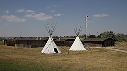
 Reconstructed buildings at the site of Fort Caspar | |
 | |
| Location | 14 Fort Caspar Rd. Casper, Wyoming 82604 |
|---|---|
| Coordinates | 42°50′12″N 106°22′16″W / 42.83667°N 106.37111°W |
| Architect | Louis Guinard |
| NRHP reference No. | 71000887; 76002282 |
| Added to NRHP | August 12, 1971; July 19, 1976 |
Fort Caspar was a military post of the United States Army in present-day Wyoming, named after 2nd Lieutenant Caspar Collins, a U.S. Army officer who was killed in the 1865 Battle of the Platte Bridge Station against the Lakota and Cheyenne. Founded in 1859 along the banks of the North Platte River as a trading post and toll bridge on the Oregon Trail, the post was later taken over by the Army and named Platte Bridge Station to protect emigrants and the telegraph line against raids from Lakota and Cheyenne in the ongoing wars between those nations and the United States. The site of the fort, near the intersection of 13th Street and Wyoming Boulevard in Casper, Wyoming, is listed in the National Register of Historic Places and is now owned and operated by the City of Casper as the Fort Caspar Museum and Historic Site.