Fort Recovery Site | |
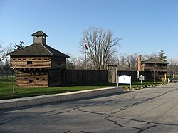
 Blockhouses and stockade walls at the reproduction of Fort Recovery | |
| Location | State Route 49, Fort Recovery, Ohio |
|---|---|
| Coordinates | 40°24′50″N 84°46′51″W / 40.41389°N 84.78083°W |
| Area | 5 acres (2.0 ha) |
| Built | 1791 |
| NRHP reference No. | 70000509[1] |
| Added to NRHP | November 10, 1970 |
Fort Recovery was a United States Army fort ordered built by General "Mad" Anthony Wayne during what is now termed the Northwest Indian War. Constructed from late 1793 and completed in March 1794, the fort was built along the Wabash River, within two miles of what became the Ohio state border with Indiana. A detachment of Wayne's Legion of the United States held off an attack from combined Indian forces on June 30, 1794. The fort was used as a reference in drawing treaty lines for the 1795 Treaty of Greenville, and for later settlement. The fort was abandoned in 1796.
The present-day village of Fort Recovery, Ohio developed around the fort and along the river. It includes sites and monuments to commemorate the fort and battles in the area.

