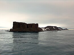
 Fort William (in the foreground) from English Strait | |
 Location of Robert Island in the South Shetland Islands | |
| Geography | |
|---|---|
| Location | Antarctica |
| Coordinates | 62°22′13″S 59°43′33″W / 62.37028°S 59.72583°W |
| Archipelago | South Shetland Islands |
| Administration | |
| Administered under the Antarctic Treaty System | |
| Demographics | |
| Population | 0 |
| Fort William Lighthouse | |
| Foundation | concrete base |
| Construction | fiber glass tower[1] |
| Height | 3 m (9.8 ft) |
| Shape | cylindrical tower with lantern[1] |
| Markings | white and red horizontal bands tower[1] |
| Power source | solar power |
| Focal height | 10 m (33 ft) |
| Range | 5 nmi (9.3 km; 5.8 mi) |
| Characteristic | Fl W 5s |
Fort William Point is the conspicuous flat-topped rocky headland forming the northwest extremity of Coppermine Peninsula and Robert Island in the South Shetland Islands, Antarctica. The point is a northwest entrance point of English Strait and forms the west side of the entrance to Carlota Cove.
The feature was named by the early 19th century sealers who used it as a landmark for entering English Strait from the north.