| Fort Yargo State Park | |
|---|---|
 | |
| Location | Barrow County, Georgia, US |
| Nearest city | Winder, Georgia |
| Coordinates | 33°58′11″N 83°43′47″W / 33.969621°N 83.729612°W |
| Area | 1,816 acres (7.35 km2) |
| Governing body | Georgia State Park |
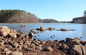
Fort Yargo State Park is a 1,816-acre (7.35 km2) U.S. state park located in Winder, Georgia, situated between Athens and Atlanta. The park is located 1 mile south of Winder and is accessible by Georgia State Route 81. There is a 260-acre (1.1 km2) lake with a public beach. Available activities at Fort Yargo include GeoCaching, hiking, mountain biking, disc golf, boating (including Jon boat, pedal boat, and canoe rentals), lake swimming, fishing, picnicking, and miniature golf. The park also features a log fort built in 1792 by settlers, for protection against the Creek and Cherokee.[1]
The park also hosts Camp Will-A-Way, an accessible camp designed for individuals with developmental disabilities, in partnership with Camp Twin Lakes.[2][3]
- ^ "Fort Yargo State Park".
- ^ "Camp Twin Lakes - Will-A-Way" (PDF). CampTwinLakes.org. Retrieved September 25, 2017.
- ^ "Will-A-Way - Camp Twin Lakes". Camp Twin Lakes. Retrieved September 25, 2017.

