| Fortifications of Heraklion | |
|---|---|
| Heraklion, Crete, Greece | |
 Bethlehem Bastion | |
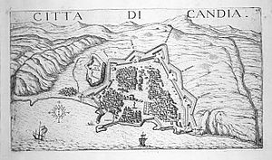
 Map of Candia (Heraklion) and its fortifications in 1651 | |
| Coordinates | 35°20′3.3″N 25°7′37.8″E / 35.334250°N 25.127167°E |
| Type | City wall |
| Site information | |
| Open to the public | Yes |
| Condition | Mostly intact |
| Site history | |
| Built | c. 9th–10th centuries (Arab and Byzantine walls) 1462–16th century (Venetian walls) |
| Built by | Byzantine Empire Emirate of Crete Republic of Venice |
| Battles/wars | Siege of Candia |

The fortifications of Heraklion are a series of defensive walls and other fortifications which surround the city of Heraklion (formerly Candia) in Crete, Greece. The first city walls were built in the Middle Ages, but they were completely rebuilt by the Republic of Venice.[1] The fortifications managed to withstand the second longest siege in history for 21 years, before the city fell to the Ottomans in 1669.
Heraklion's fortifications have made it one of the best fortified cities in the Mediterranean.[2] The walls remain largely intact to this day, and they are considered to be among the best preserved Venetian fortifications in Europe.[3]
- ^ Cosmescu, D. Venetian Renaissance Fortifications in the Mediterranean, McFarland, 2005. ISBN 1476620180.
- ^ Wass, Stephen. "Heraklion". fortified-places.com. Archived from the original on 18 May 2015.
- ^ "The Castle of Candia (Heraklion)". cretanbeaches. Archived from the original on 6 February 2012.