Fostoria, Ohio | |
|---|---|
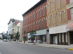
 Main Street in downtown Fostoria | |
 Location of Fostoria, Ohio | |
 Location of Fostoria in Seneca County | |
| Coordinates: 41°09′47″N 83°23′55″W / 41.16306°N 83.39861°W | |
| Country | United States |
| State | Ohio |
| Counties | Seneca, Hancock, Wood |
| Area | |
| • Total | 7.79 sq mi (20.18 km2) |
| • Land | 7.57 sq mi (19.62 km2) |
| • Water | 0.22 sq mi (0.56 km2) |
| Elevation | 774 ft (236 m) |
| Population (2020) | |
| • Total | 13,046 |
| • Estimate (2023)[3] | 13,039 |
| • Density | 1,722.47/sq mi (665.05/km2) |
| Time zone | UTC-5 (Eastern (EST)) |
| • Summer (DST) | UTC-4 (EDT) |
| ZIP code | 44830 |
| Area code(s) | 419, 567 |
| FIPS code | 39-28014[4] |
| GNIS feature ID | 1086945[2] |
| Website | fostoriaohio.gov |
Fostoria (/fɒsˈtʊəriːə/, foss-TORR-EE-ə) is a city located at the convergence of Hancock, Seneca, and Wood counties[5] in the northwestern part of the U.S. state of Ohio. The population was 13,046 at the 2020 Census,[6] slightly down from 13,441 at the 2010 Census.[7] It is approximately 40 miles (64 km) south of Toledo and 90 miles (140 km) north of Columbus. The community grew substantially during the end of the 19th century, coinciding with the northwest Ohio gas boom. Typical of Rust Belt cities, Fostoria peaked in size in 1970.
Fostoria was a major site for the glass industry, having over a dozen glass factories during the end of the 19th century. As the area's gas supply became depleted, many of the factories closed or moved. The city is now known for its railroads, as approximately 100 trains pass through the city each day. As a result, the city is often visited by railfans, hosted by a railroad viewing park.
- ^ "ArcGIS REST Services Directory". United States Census Bureau. Retrieved September 20, 2022.
- ^ a b U.S. Geological Survey Geographic Names Information System: Fostoria, Ohio
- ^ "Annual Estimates of the Resident Population for Incorporated Places in Ohio: April 1, 2020 to July 1, 2023". United States Census Bureau. Retrieved June 25, 2024.
- ^ "U.S. Census website". United States Census Bureau. Retrieved January 31, 2008.
- ^ Chisholm, Hugh, ed. (1911). . Encyclopædia Britannica. Vol. 10 (11th ed.). Cambridge University Press. pp. 733–734.
- ^ 2020 United States Census, Fostoria, Ohio Total Population, https://www.census.gov/search-results.html?searchType=web&cssp=SERP&q=Fostoria%20city,%20Ohio
- ^ "Geographic Identifiers: 2010 Demographic Profile Data (G001): Fostoria city, Ohio". U.S. Census Bureau, American Factfinder. Archived from the original on February 12, 2020. Retrieved January 18, 2013.

