| Fourmile Canyon fire | |
|---|---|
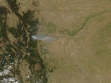
 The Fourmile Canyon Fire continued to burn on September 7, 2010, visible from NASA's Aqua satellite. | |
| Date(s) | September 6, 2010 — September 16, 2010 |
| Coordinates | 40°02′53″N 105°23′24″W / 40.048°N 105.39°W |
| Map | |
This article needs additional citations for verification. (December 2009) |
Fourmile Canyon or Four Mile Canyon is a mountainous canyon in western Boulder County, Colorado that channels a stream known as Fourmile Creek or Four Mile Creek (this is not Fourmile Canyon Creek which runs a few miles north of Fourmile Creek).[1]). The stream rises at 40°02′53″N 105°33′00″W / 40.048°N 105.550°W on the southern slope of Niwot Mountain, before flowing east and south through the unincorporated communities of Sunset, Wallstreet, Salina and Crisman to the confluence with Boulder Creek at 40°00′54″N 105°19′26″W / 40.015°N 105.324°W in Boulder Canyon, four miles west of the historic location of the Boulder Railroad Depot.
The canyon and surrounding area were the site of an eponymous major wildfire in September 2010.
- ^ "Fourmile Canyon Creek". Boulder Area Sustainability Network. Retrieved 14 September 2013.
