Framingham | |
|---|---|
|
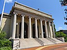
Left-right from top: Memorial Hall in Concord Square Historic District, Framingham Common, Framingham State University, Callahan State Park | |
 Location in Middlesex County in Massachusetts | |
| Coordinates: 42°16′45″N 71°25′00″W / 42.27917°N 71.41667°W | |
| Country | United States |
| State | Massachusetts |
| County | Middlesex |
| Region | New England |
| Settled | 1650 |
| Incorporated (town) | June 25, 1700 |
| Incorporated (city) | January 1, 2018 |
| Government | |
| • Type | City |
| • Mayor | Charlie Sisitsky |
| • City council | Phillip Ottaviani, Chair Tracey Bryant, Vice-Chair George King Janet Leombruno Christine Long Brandon Ward Adam Steiner Michael Cannon Noval Alexander Leora Mallach Leslie White Harvey |
| Area | |
| • Total | 26.50 sq mi (68.65 km2) |
| • Land | 25.04 sq mi (64.86 km2) |
| • Water | 1.46 sq mi (3.78 km2) |
| Elevation | 165 ft (50 m) |
| Population (2020) | |
| • Total | 72,362 |
| • Density | 2,889.39/sq mi (1,115.61/km2) |
| Time zone | UTC−5 (Eastern) |
| • Summer (DST) | UTC−4 (Eastern) |
| ZIP Codes | 01701 and 01702 |
| Area code | 508/774 |
| FIPS code | 25-24960 |
| GNIS feature ID | 0618224 |
| Website | www |
Framingham (/ˈfreɪmɪŋhæm/ ) is a city in the Commonwealth of Massachusetts, United States. Incorporated in 1700, it is located in Middlesex County and the MetroWest subregion of the Greater Boston metropolitan area. The city proper covers 25 square miles (65 km2) with a population of 72,362 in 2020,[2] making it the 14th most populous municipality in Massachusetts.[3] Residents voted in favor of adopting a charter to transition from a representative town meeting system to a mayor–council government in April 2017, and the municipality transitioned to city status on January 1, 2018. Before it transitioned, it had been the largest town by population in Massachusetts.[4][5]
The city has one of the largest Brazilian American populations in the United States, with a considerable Brazilian presence since the 1980s.[6][7][8][9]
- ^ "2020 U.S. Gazetteer Files (Massachusetts)". United States Census Bureau. Retrieved May 21, 2022.
- ^ "Census - Geography Profile: Framingham town, Middlesex County, Massachusetts". U.S. Census Bureau. Retrieved September 18, 2021.
- ^ "Census 2020 Data for Massachusetts". University of Massachusetts Donahue Institute. Retrieved September 18, 2021.
- ^ "Framingham, Formerly Massachusetts' Largest Town, Votes to Become City". CBS News. April 4, 2017.
- ^ "Recount confirms Framingham votes to become a city". Boston Herald. April 25, 2017. Archived from the original on June 12, 2018. Retrieved April 25, 2017.
- ^ "Brazil - Brasil - BRAZZIL - News from Brazil - Brazilian Is Not Hispanic - Brazilian Culture - October 2003". Brazzil. Archived from the original on September 20, 2016. Retrieved March 25, 2017.
- ^ "U.S. Census website". United States Census Bureau. Retrieved April 20, 2007.
- ^ Joel Millman (February 16, 2006). "Immigrant groups put new spin on cleaning niche". The Wall Street Journal – via Pittsburgh Post-Gazette.
- ^ "Migration and Refugee Services". Usccb.org. Archived from the original on June 7, 2011. Retrieved March 25, 2017.


