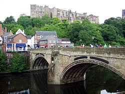
Framwellgate Bridge | |
|---|---|
 Framwellgate Bridge, in 2011 | |
| Coordinates | 54°46′34″N 1°34′41″W / 54.7761°N 1.5781°W |
| OS grid reference | NZ272424 |
| Carries | Pedestrians |
| Crosses | River Wear |
| Locale | City of Durham, County Durham, England |
| Heritage status | Grade I listed |
| Preceded by | Prebends Bridge |
| Followed by | Milburngate Bridge |
| Characteristics | |
| Design | Two segmental arches with seven reinforcing ribs. Central pier with cutwaters. Possible third arch (no longer visible). |
| Material | Stone |
| Total length | 2 main spans total 30 yd (27 m) |
| Width | 27 ft (8.2 m) |
| No. of spans | 2 known; probably 3 total |
| Piers in water | 1 |
| History | |
| Construction start | After 1400 |
| Construction end | 15th century |
| Replaces | Stone bridge built circa 1120 |
| Location | |
 | |
Framwellgate Bridge is a medieval masonry arch bridge across the River Wear, in Durham, England. It is a Grade I listed building.[1]
- ^ Historic England (6 May 1952). "Framwellgate Bridge (1322872)". National Heritage List for England. Retrieved 5 February 2018.