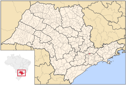
Francisco Morato | |
|---|---|
Municipality | |
 Location in São Paulo state | |
| Coordinates: 23°16′54″S 46°44′33″W / 23.28167°S 46.74250°W | |
| Country | Brazil |
| Region | Southeast Brazil |
| State | São Paulo |
| Metropolitan Region | São Paulo |
| Government | |
| • Prefect | Ildo Gusmão |
| Area | |
| • Total | 49.00 km2 (18.92 sq mi) |
| Population (2020[1]) | |
| • Total | 177,633 |
| • Density | 3,600/km2 (9,400/sq mi) |
| Time zone | UTC−3 (BRT) |
Francisco Morato is a suburban city in the state of São Paulo in Brazil. It is part of the Metropolitan Region of São Paulo.[2] The population is 177,633 (2020 est.) in an area of 49.00 km2 (18.92 sq mi).[3] The suburban city is served by the CPTM Line 7.
The population according to the census carried out by IBGE in 2022 was 165,139 inhabitants and has an area of 49,001 km², which results in a population density of 3,370 inhabitants/km². It became a municipality in 1965, when it became independent from Franco da Rocha.[4]
- ^ IBGE 2020
- ^ Lei Complementar nº 1.139, de 16 de junho de 2011
- ^ Instituto Brasileiro de Geografia e Estatística
- ^ "Francisco Morato – Guia do cidade Francisco Morato -SP Aqui você Encontra !". www.encontrafranciscomorato.com.br (in Brazilian Portuguese). Retrieved 9 October 2024.


