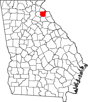
Franklin County | |
|---|---|
 Franklin County Courthouse in Carnesville | |
 Location within the U.S. state of Georgia | |
 Georgia's location within the U.S. | |
| Coordinates: 34°22′N 83°14′W / 34.37°N 83.23°W | |
| Country | |
| State | |
| Founded | February 25, 1784 |
| Named for | Benjamin Franklin |
| Seat | Carnesville |
| Largest city | Lavonia |
| Area | |
| • Total | 266 sq mi (690 km2) |
| • Land | 261 sq mi (680 km2) |
| • Water | 5.0 sq mi (13 km2) 1.15% |
| Population (2020) | |
| • Total | 23,424 |
| • Estimate (2023) | 24,782 |
| • Density | 88/sq mi (34/km2) |
| Time zone | UTC−5 (Eastern) |
| • Summer (DST) | UTC−4 (EDT) |
| Congressional district | 9th |
| Website | www |
Franklin County is a county in the Northeast region of the U.S. state of Georgia. As of the 2020 census, the population was 23,424.[1] The county seat is Carnesville.[2] On February 25, 1784, Franklin and Washington became Georgia's eighth and ninth counties,[3] with Franklin named in honor of patriot Benjamin Franklin.[4]
In its original form, Franklin County included all of the territory now in Banks, Barrow, Clarke, Jackson, Oconee, and Stephens counties, and parts of the modern-day Gwinnett, Hall, Hart, and Madison counties, as well as three counties that are now part of South Carolina. Franklin County has several miles of shoreline on Lake Hartwell.
- ^ "Census - Geography Profile: Franklin County, Georgia". United States Census Bureau. Retrieved December 27, 2022.
- ^ "Find a County". National Association of Counties. Archived from the original on May 31, 2011. Retrieved June 7, 2011.
- ^ "Franklin County : County Profile". Georgia State Government. Retrieved September 5, 2011.
- ^ Gannett, Henry (1905). The Origin of Certain Place Names in the United States. Govt. Print. Off. pp. 131.