Franklin County | |
|---|---|
 Franklin County Courthouse in Louisburg | |
| Motto(s): "Leges Juraque Vindicamus" (Latin) (We Defend Laws and Justice) "A Research Triangle Region Community" | |
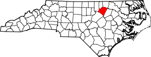
 Location within the U.S. state of North Carolina | |
 North Carolina's location within the U.S. | |
| Coordinates: 36°05′N 78°17′W / 36.09°N 78.28°W | |
| Country | |
| State | |
| Founded | 1779 |
| Named for | Benjamin Franklin |
| Seat | Louisburg |
| Largest community | Louisburg |
| Area | |
• Total | 494.57 sq mi (1,280.9 km2) |
| • Land | 491.80 sq mi (1,273.8 km2) |
| • Water | 2.77 sq mi (7.2 km2) 0.56% |
| Population (2020) | |
• Total | 68,573 |
• Estimate (2023) | 77,001 |
| • Density | 140/sq mi (54/km2) |
| Time zone | UTC−5 (Eastern) |
| • Summer (DST) | UTC−4 (EDT) |
| Congressional district | 1st |
| Website | www |
Franklin County is a county located in the U.S. state of North Carolina. As of the 2020 census, the population was 68,573.[1] Its county seat is Louisburg.[2] Franklin County is included in the Raleigh-Cary, NC Metropolitan Statistical Area, which is also included in the Raleigh-Durham-Cary, NC Combined Statistical Area, which had an estimated population of 2,368,947 in 2023.[3]
- ^ Cite error: The named reference
2020CensusQuickFactswas invoked but never defined (see the help page). - ^ "Find a County". National Association of Counties. Archived from the original on May 31, 2011. Retrieved June 7, 2011.
- ^ "Metropolitan and Micropolitan Statistical Areas Population Totals: 2020-2023". United States Census Bureau, Population Division. March 14, 2024. Retrieved March 15, 2024.
