| Franks Tract State Recreation Area | |
|---|---|
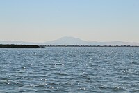
 Franks Tract with Mount Diablo in the background | |
 | |
| Location | Sacramento-San Joaquin Delta |
| Nearest city | Oakley, California |
| Designation | State Recreation Area[1] |
| Designated | 1959 |
| Owner | California Department of Parks and Recreation |
Franks Tract State Recreation Area (SRA) is a state park unit of California, United States, featuring a flooded area in the Sacramento–San Joaquin River Delta. It is accessible only by water. Franks Tract, and a smaller adjoining submerged property called "Little Franks Tract", are situated between the False River and Bethel Island. The recreation area is used primarily for fishing and waterfowl hunting, because of its exposure to frequent strong winds and fluctuating water levels. In times of high water, the entire site can be submerged except for portions of the old levees.[2] The 3,523-acre (1,426 ha) park was established in 1959.[3] It is managed from nearby Brannan Island State Recreation Area, 6 miles (9.7 km) to the northwest.[4]
- ^ Cite error: The named reference
CSMMwas invoked but never defined (see the help page). - ^ "Franks Tract SRA". California State Parks. Retrieved 2012-01-14.
- ^ "California State Park System Statistical Report: Fiscal Year 2009/10" (PDF). California State Parks: 20. Retrieved 2011-12-30.
{{cite journal}}: Cite journal requires|journal=(help) - ^ "Brannen Island/Franks Tract State Recreation Areas" (PDF). California State Parks. 2011. Archived from the original (PDF) on 2015-12-21. Retrieved 2012-01-14.