Friant | |
|---|---|
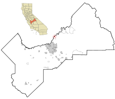
 Location in Fresno County and the state of California | |
| Coordinates: 36°59′16″N 119°42′43″W / 36.98778°N 119.71194°W[1] | |
| Country | |
| State | |
| County | Fresno |
| Government | |
| • State Senator | Angelique Ashby (D)[2] |
| • State Assembly | Marc Berman (D)[3] |
| • U. S. Congress | David Valadao (R)[4] |
| Area | |
| • Total | 1.325 sq mi (3.434 km2) |
| • Land | 1.275 sq mi (3.303 km2) |
| • Water | 0.050 sq mi (0.131 km2) 3.8% |
| Elevation | 344 ft (105 m) |
| Population | |
| • Total | 446 |
| • Density | 340/sq mi (130/km2) |
| Time zone | UTC-8 (PST) |
| • Summer (DST) | UTC-7 (PDT) |
| ZIP code | 93626 |
| Area code | 559 |
| FIPS code | 06-27014 |
| GNIS feature IDs | 223946, 2408265 |
Friant (formerly, Converse Ferry, Jones Ferry, Hamptonville, and Pollasky)[7] is a census-designated place (CDP) in Fresno County, California, United States. The population was 549 at the 2010 census, down from 778 at the 2000 census. Friant is located 11.5 miles (19 km) north of Clovis,[7] at an elevation of 344 feet (105 m).[1]
- ^ a b c "Friant". Geographic Names Information System. United States Geological Survey, United States Department of the Interior.
- ^ "Senators". State of California. Retrieved April 6, 2013.
- ^ "Members Assembly". State of California. Retrieved April 6, 2013.
- ^ "California's 22nd Congressional District - Representatives & District Map". Civic Impulse, LLC. Retrieved April 6, 2013.
- ^ "2010 Census U.S. Gazetteer Files – Places – California". United States Census Bureau.
- ^ "US Census Bureau". www.census.gov. Retrieved August 21, 2024.
- ^ a b Durham, David L. (1998). California's Geographic Names: A Gazetteer of Historic and Modern Names of the State. Clovis, Calif.: Word Dancer Press. p. 1038. ISBN 1-884995-14-4.
