| Friant Dam | |
|---|---|
 | |
| Country | United States |
| Location | Madera/Fresno Counties, California |
| Coordinates | 37°00′02″N 119°42′19″W / 37.00056°N 119.70528°W |
| Construction began | 1937 |
| Opening date | 1942 |
| Owner(s) | Central Valley Project United States Bureau of Reclamation |
| Dam and spillways | |
| Type of dam | Concrete gravity |
| Impounds | San Joaquin River |
| Height | 319 ft (97 m)[1] |
| Length | 3,488 ft (1,063 m)[1] |
| Width (base) | 267 ft (81 m)[1] |
| Spillway type | Gated overflow, 1 center flotation drum gate, 2 obermeyer pneumatically actuated gates. |
| Spillway capacity | 83,000 cu ft/s (2,400 m3/s)[2] |
| Reservoir | |
| Creates | Millerton Lake |
| Total capacity | 520,528 acre⋅ft (642,062 dam3)[2] |
| Inactive capacity | 120,000 acre⋅ft (150,000 dam3)[3] |
| Catchment area | 1,638 sq mi (4,240 km2)[4] |
| Surface area | 4,900 acres (2,000 ha)[2] |
| Power Station | |
| Turbines | 1x 15 MW, 1x 8 MW, 1x 2 MW[4] |
| Installed capacity | 25 MW[4] |
| Annual generation | 81,409,000 KWh |

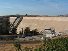
Friant Dam is a concrete gravity dam on the San Joaquin River in central California in the United States, on the boundary of Fresno and Madera Counties. It was built between 1937 and 1942 as part of a U.S. Bureau of Reclamation (USBR) water project to provide irrigation water to the southern San Joaquin Valley. The dam impounds Millerton Lake, a 4,900-acre (2,000 ha) reservoir about 15 miles (24 km) north of Fresno.
- ^ a b c "Friant Dam – Dimensions". Friant Division Project. U.S. Bureau of Reclamation. 2009-06-04. Retrieved 2012-04-04.
- ^ a b c Cite error: The named reference
FriantDivisionwas invoked but never defined (see the help page). - ^ Ritzema, Randall S.; Newlin, Brad D.; Van Lienden, Brian J. (October 2001). "Appendix H: Infrastructure" (PDF). CALVIN Project. University of California Davis. Archived from the original (PDF) on 2017-11-06. Retrieved 2014-01-25.
- ^ a b c "Draft Background Report on Friant Dam Operations" (PDF). San Joaquin River Restoration Program. 2008-02-07. Archived from the original (PDF) on 2011-10-18. Retrieved 2012-04-04.